The Lucas Fire has exploded across Northern California, growing from a small vegetation fire near Potter Valley on Thursday, September 10, into a fast-moving wildfire covering roughly 3,466 acres by September 12, according to the latest CAL FIRE incident data. The blaze is burning near the Lake County–Mendocino County line, with evacuations, road closures and emergency forest restrictions affecting communities and outdoor recreation areas around the northern edge of the Mendocino National Forest.
The speed of the expansion is what makes the Lucas Fire significant. CAL FIRE initially reported approximately 10 acres burning in grass and oak in a remote Potter Valley location at 10:50 a.m. on September 10. By late afternoon, the fire had reached 400 acres, and by 8:31 p.m. it had been mapped at approximately 1,099 acres. The following day, the fire surged to more than 3,400 acres as strong winds and dry vegetation helped drive rapid growth.
As of the latest available incident information, the cause remains under investigation, while firefighters are working in steep and difficult terrain and protecting communities threatened by the fire.
The Lucas Fire Grew From 10 Acres To More Than 3,400
The Lucas Fire began at approximately 9:18 a.m. on September 10 near Potter Valley, northeast of Ukiah and northwest of Clear Lake. CAL FIRE initially described the fire as burning in grass and oak in a remote area.
Its growth during the first day was unusually rapid.
At 2:39 p.m., CAL FIRE reported the fire at 40 acres with zero containment. Less than three hours later, the reported size had reached approximately 400 acres. By 7:51 p.m., the fire had grown to 1,099 acres and achieved just 5% containment.
The next major increase came on September 11. CAL FIRE reported the fire at 3,476 acres and 5% containment during the afternoon, while the latest statewide incident listing places the Lucas Fire at approximately 3,466 acres and 10% containment.
| Lucas Fire Timeline | Reported Size / Status |
|---|---|
| September 10, 10:50 a.m. | About 10 acres |
| September 10, 2:39 p.m. | 40 acres, 0% contained |
| September 10, 5:29 p.m. | 400 acres, 0% contained |
| September 10, 7:51 p.m. | 1,099 acres, 5% contained |
| September 11, afternoon | 3,476 acres, 5% contained |
| September 12, latest listing | About 3,466 acres, 10% contained |
That progression is important because it shows why evacuation boundaries expanded so quickly. The fire was not simply growing steadily across a predictable perimeter. It was moving through terrain where access is difficult and where wind could rapidly change the direction and intensity of fire behavior.
The latest CAL FIRE incident information remains the most authoritative source for acreage, containment and evacuation updates because incident figures can change several times during a single operational period.
Steep Terrain Is Making Firefighting More Difficult
The location of the Lucas Fire is a major factor in the response.
The fire is burning in and around the rugged landscape near Potter Valley, close to the boundary between Lake and Mendocino counties. CAL FIRE described the initial fire as occurring in a remote area, and later updates noted significantly increased fire activity and difficult access.
Remote terrain creates several problems for firefighters.
Ground crews need safe routes to reach the fireline. Engines and water tenders require roads that may not exist close to the active perimeter. Steep slopes can make direct suppression dangerous, while vegetation and wind can allow flames to move faster than crews can establish containment lines.
Aircraft can provide a critical advantage under those circumstances.
CAL FIRE ordered night-flying helicopters as fire activity increased on September 10, and numerous air tankers have since been assigned to suppression operations as conditions permit. The September 11 incident update listed approximately 1,000 personnel assigned to the response.
The combination of air support and ground crews is especially important when the fire approaches areas where structures and evacuation routes are at risk.
The challenge is that aircraft cannot eliminate the underlying terrain problem. Crews eventually need to establish secure containment lines, and those lines must hold when winds increase or fire behavior changes.
Evacuation Orders Now Cover Parts Of Lake And Mendocino Counties
The Lucas Fire has triggered evacuation orders and warnings across portions of the surrounding region.
Lake County has issued evacuation orders for multiple zones, including MNF-E016, MNF-E018, MNF-E019, UPP-E023, UPP-E025, UPP-E026, UPP-E027 and UPP-E030. Evacuation warnings have also been issued in additional Lake County zones, while Mendocino County has evacuation warnings affecting areas around Potter Valley and Ukiah.
The distinction between an order and a warning is critical.
An evacuation order means residents in the affected area are being directed to leave because officials have identified an immediate threat to life. A warning means there is a potential threat and residents should prepare to leave, particularly people who need additional time because of pets, livestock or mobility considerations.
Lake County activated its Emergency Operations Center on September 10 as the fire expanded. County officials established a temporary evacuation point and livestock evacuation area at the Lake County Fairgrounds in Lakeport.
The county’s emergency response shows how a wildfire in a remote area can quickly become a regional logistics operation.
Evacuees need somewhere to go. Livestock require separate arrangements. Roads need traffic control, and emergency agencies must coordinate information as evacuation zones change.
For residents, the Lake County emergency response information provides a useful official reference for current evacuation information and shelter operations.
The Lake County Fairgrounds Is Sheltering People And Livestock
The temporary evacuation point at the Lake County Fairgrounds, 401 Martin Street in Lakeport, has become an important part of the Lucas Fire response.
The Baldwin Pavilion is serving as the temporary evacuation point, while the fairgrounds are also being used for livestock evacuation. That arrangement reflects the rural character of the Potter Valley and Upper Lake area, where residents may have horses, cattle and other animals that cannot simply be left behind during an evacuation.
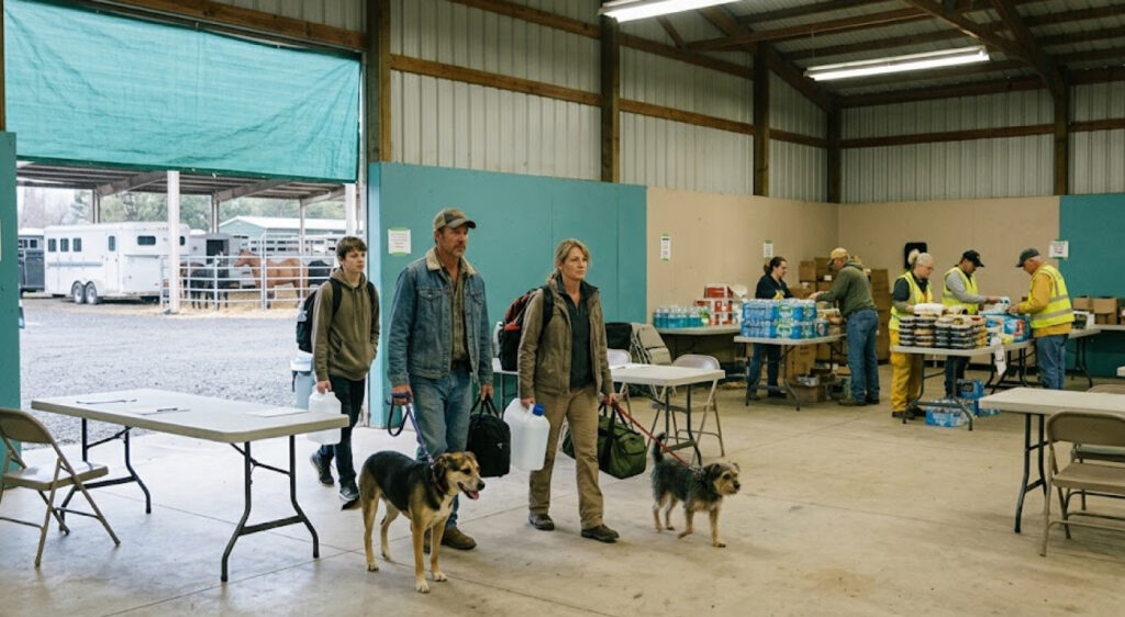
Animal evacuation is one of the most complicated elements of a fast-moving wildfire.
A household may be able to leave within minutes, but moving livestock requires trailers, transport vehicles, loading areas and suitable facilities. Residents who wait until the last moment can also face dangerous road conditions if fire behavior changes quickly.
The establishment of a livestock shelter early in the incident therefore gives agricultural residents an important option before conditions become more difficult.
Officials have also emphasized that people in evacuation warning areas who have pets or livestock should leave early rather than waiting until an evacuation order becomes necessary.
Highway 20 Has Multiple Traffic Control Points
Road access is another major concern as the Lucas Fire spreads across the Potter Valley and Upper Lake region.
Traffic control points have been established around Highway 20, with closures reported at intersections including Bachelor Valley Road, Witter Springs Road and Saratoga Springs Road.
Highway 20 is particularly important because it connects communities in Lake and Mendocino counties and provides a major east-west route through the region.
A wildfire does not have to cross a highway to disrupt it.
Smoke can reduce visibility. Fire crews may need access to road shoulders. Falling trees can create hazards, and evacuation traffic can overwhelm roads that normally carry much less traffic.
When emergency agencies establish traffic-control points, drivers should expect delays and should not attempt to bypass barricades or use closed roads.
The California Highway information system is another useful resource for travelers checking road conditions before entering the region.
For anyone planning to travel around Lake or Mendocino counties this weekend, the Lucas Fire means route planning should be based on current conditions rather than normal travel times.
PG&E Has Shut Off Power Along Elk Mountain Road
The fire has also affected utility infrastructure.
PG&E shut off power along Elk Mountain Road from White Rock Road to Middle Creek as the Lucas Fire threatened the area. The action was reported by CAL FIRE during the September 10 response.
Power shutoffs can be disruptive, but they can also be part of wildfire risk management.
Utility lines and electrical equipment can create hazards during extreme fire conditions, while firefighters need safe access to areas where poles, transformers and other infrastructure could be damaged.
For residents, an outage can create additional evacuation complications. Electric garage doors, pumps, medical equipment, refrigeration and communications equipment may all depend on electricity.
That makes emergency preparedness particularly important in rural communities.
Residents in areas affected by the Lucas Fire should have backup lighting, charged communication devices and enough supplies to leave quickly if evacuation orders change.
The priority during an active evacuation remains leaving the area safely rather than attempting to protect property.
Strong Winds Could Drive Another Round Of Fire Growth
Weather conditions are one of the biggest reasons the Lucas Fire remains a serious concern.
The fire expanded rapidly during a period of high temperatures, dry vegetation and strong winds. The National Weather Service has issued fire-weather warnings across portions of Northern California, with a Red Flag Warning beginning Saturday morning and continuing into early Sunday for areas facing critical combinations of low humidity and gusty winds.
Those conditions can dramatically alter wildfire behavior.
Wind can push flames through grass and brush faster than firefighters can establish containment lines. It can also carry embers ahead of the main fire, creating spot fires beyond the existing perimeter.
For communities near Potter Valley, this means the fire’s acreage alone does not tell the entire story.
A relatively contained perimeter can still produce dangerous behavior if wind direction changes or new growth develops outside established lines.
The National Weather Service explains that Red Flag Warnings are issued when warm temperatures, very low humidity and stronger winds combine to create conditions favorable for dangerous fire behavior.
That forecast is particularly important this weekend because the weather shift following California’s recent heat wave is bringing stronger winds to parts of the state.
Mendocino National Forest Has Closed Recreation Areas
The Lucas Fire is also disrupting outdoor recreation around the Mendocino National Forest.
The U.S. Forest Service has issued an emergency closure covering a portion of the Upper Lake Ranger District. The closure affects roads, trails and recreation areas, including Middle Creek, Penny Pines and Deer Valley.
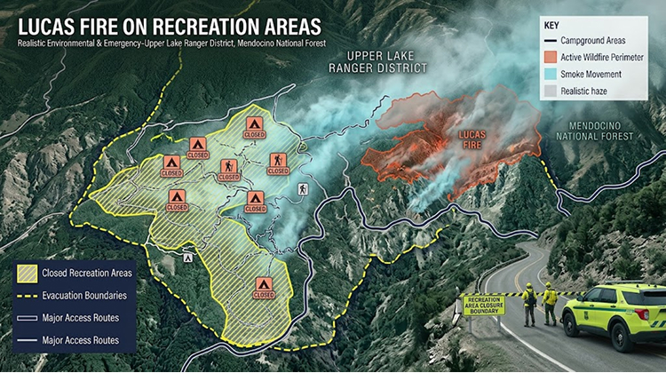
That means the impact extends beyond residents living directly in the fire area.
Campers, hikers, hunters and other forest visitors may encounter closed roads and recreation sites even if they are not close enough to see the fire.
The closures serve two purposes. They reduce the number of civilians who could become trapped if fire behavior changes, and they keep roads available for firefighting vehicles and emergency operations.
This is a familiar pattern during major California wildfires. Public lands can remain technically accessible in surrounding areas while individual roads, trail systems and campgrounds are closed because they sit inside or near the operational footprint.
For outdoor travelers, the lesson is straightforward: a recreation site that was open earlier in the week can become inaccessible within hours during a rapidly expanding wildfire.
CaliforniaTimes recently covered another example of how fire management can temporarily alter public access through its Angel Island prescribed burn coverage, although the Lucas Fire is a very different type of incident. The comparison illustrates how California’s parks and forests increasingly have to manage visitor access around changing fire conditions.
Smoke Could Affect Air Quality Beyond The Fire Area
Smoke from the Lucas Fire may also spread well beyond the immediate evacuation zones.
The fire’s location near Potter Valley means communities in Lake County and Mendocino County could experience periods of degraded air quality depending on wind direction and fire intensity. The latest reporting warns that smoke could affect Lake County and surrounding communities.
Smoke exposure is a different risk from the direct threat posed by flames.
People who live far enough away to be outside evacuation zones can still experience respiratory irritation when smoke concentrations increase. Children, older adults and people with respiratory or cardiovascular conditions can be particularly sensitive.
Outdoor recreation should therefore be evaluated based on air-quality conditions rather than distance from the fire alone.
Hikers or campers who see smoke in the distance should not assume they are safe simply because they are outside the evacuation perimeter.
The AirNow California smoke information can help residents and visitors monitor changing air-quality conditions before spending extended periods outdoors.
The Cause Of The Lucas Fire Remains Under Investigation
Officials have not identified a cause for the Lucas Fire.
CAL FIRE currently lists the cause as under investigation, meaning there is not enough verified information to attribute the ignition to equipment, human activity, lightning or another source.
That distinction matters because rapidly spreading wildfires often generate speculation before investigators have completed their work.
The Lucas Fire began in a remote area containing grass and oak vegetation. The initial reports do not establish what ignited it.
Investigators will typically examine the origin area, weather conditions, available evidence and potential human or infrastructure-related ignition sources.
Until that investigation is complete, the responsible approach is to treat the cause as unknown.
Lucas Fire Adds Another Major Incident To California’s 2026 Fire Season
The Lucas Fire is becoming one of California’s more significant active incidents even though it began only on September 10.
CAL FIRE’s statewide incident list shows the fire at approximately 3,466 acres and 10% containment, placing it among the larger active wildfires in California. Other major active fires include the 29,942-acre Plaskett Fire and 25,420-acre Timber Fire in Monterey County.
That context matters because California’s 2026 fire season has already produced several large incidents across different parts of the state.
The Lucas Fire is different in one important respect: its growth has occurred extremely quickly.
A fire that reaches several thousand acres within roughly two days puts enormous pressure on emergency managers, evacuation planners and firefighting resources.
The response must simultaneously protect structures, establish containment, maintain evacuation routes, manage forest closures, support displaced residents and monitor weather.
What Residents And Visitors Should Watch Next
The Lucas Fire’s next major developments will likely depend on three factors: wind, containment-line progress and evacuation-zone changes.
Residents should continue monitoring official Lake County, Mendocino County and CAL FIRE alerts rather than relying on social-media reports or older evacuation maps.
For outdoor visitors, the situation is even more straightforward: closed forest roads, trails and campgrounds should remain off-limits until officials reopen them.
The most important precautions are:
- Follow evacuation orders immediately and leave before roads become congested.
- Monitor official fire and road-closure information before traveling near Potter Valley, Upper Lake or the Mendocino National Forest.
- Do not enter closed trails, campgrounds or forest roads.
- Prepare pets and livestock before an evacuation order becomes urgent.
- Check smoke and air-quality conditions before outdoor activities.
- Avoid using unofficial shortcuts around traffic-control points.
The Lucas Fire demonstrates how quickly conditions can change in Northern California.
At 10 acres, it was a remote vegetation fire.
By that evening, it had exceeded 1,000 acres.
By September 11, it had expanded beyond 3,400 acres and forced a much broader regional response.
For Potter Valley, Upper Lake and communities surrounding the Mendocino National Forest, the immediate priority remains containment and safe evacuation. For California’s outdoor community, the fire is another reminder that September can bring some of the state’s most difficult wildfire conditions, even as temperatures begin to change and summer recreation normally starts shifting into its fall pattern.