Smoke rising from the middle of San Francisco Bay will look unusual this week, but officials say it is planned.
California State Parks, CAL FIRE and the Marin County Fire Department are preparing to conduct a prescribed burn covering up to 260 acres at Angel Island State Park, with ignition scheduled to begin as early as Tuesday, September 8, 2026, if weather and air-quality conditions allow. The operation could continue through the week, bringing temporary trail and road closures to one of the Bay Area’s most recognizable recreation destinations.
The island itself will remain open during burn operations. That distinction matters for visitors because this is not a park-wide closure. Instead, State Parks will restrict access around active burn areas, with portions of the Ida Trail, Sunset Trail, fire roads and perimeter roads potentially closed for one to three days during and immediately after the operation. Access to the summit of Mount Livermore will also be restricted on some burn days.
For people watching from Tiburon, San Francisco, Sausalito and other Bay Area communities, the most visible part of the operation will be smoke. Officials expect smoke to be visible from approximately 9 a.m. to 6 p.m. on burn days, with some haze potentially lingering for as long as three days after ignition.
The prescribed fire is part of a much larger shift in how California manages vegetation, wildfire risk and public lands. Rather than waiting for an uncontrolled fire to determine when and where vegetation burns, land managers are using carefully planned fire to reduce accumulated fuels, manage invasive plants and improve habitat.
Why Angel Island Is Burning Up To 260 Acres
Angel Island may be surrounded by water, but its isolation does not eliminate wildfire risk.
The park covers approximately 740 acres, making the planned 260-acre treatment a significant portion of the island. Angel Island is the largest island in San Francisco Bay and sits roughly one mile from the Tiburon Peninsula. Its terrain includes grasslands, coastal scrub, forested slopes and rugged shoreline.
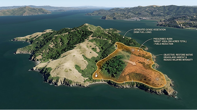
The current operation specifically targets grasslands and coastal scrub where managers want to reduce accumulated fuel.
California State Parks says the prescribed burn has several objectives: reducing fuel loads, improving wildlife habitat, managing invasive vegetation and supporting long-term vegetation management. The project is also supported by Proposition 4, the $10 billion climate bond approved by California voters in 2024.
The strategy is especially relevant in a state where wildfire preparation increasingly includes landscapes that are not traditionally associated with large forest fires.
Angel Island’s vegetation is surrounded by one of the country’s busiest urban regions. A large uncontrolled fire on the island could create smoke impacts across nearby communities and require fire crews to respond in a difficult environment where access depends heavily on boats and limited roads.
That makes reducing fuel before a wildfire starts a practical emergency-management strategy.
The California State Parks prescribed fire program explains that prescribed burns are planned around specific environmental and operational conditions, with State Parks working with fire agencies and monitoring agencies before and during ignition.
The Park Will Stay Open, But Several Trails May Close
Visitors should not interpret the prescribed burn as a complete shutdown of Angel Island.
State Parks currently lists the park as open with restrictions, while the prescribed burn is scheduled to begin as early as September 8. The agency has emphasized that closures will focus on areas near active burning and may change depending on daily conditions.
That means a visitor arriving at Ayala Cove could still find the park operating while discovering that a favorite route is temporarily inaccessible.
| Visitor Area | Expected Status During Burn |
|---|---|
| Angel Island State Park | Open with restrictions |
| Ida Trail | Portions may close |
| Sunset Trail | Portions may close |
| Fire roads | Closures possible |
| Perimeter roads | Closures possible |
| Mount Livermore summit | May be restricted on burn days |
| Other park areas | Subject to staff and fire personnel directions |
The closure period around individual burn areas is expected to last one to three days, although the schedule depends on where crews are working and whether conditions permit the planned ignition.
This makes checking the park’s status before boarding a ferry particularly important. Conditions can change even after visitors have already made travel arrangements.
Angel Island has several activities beyond hiking, including bicycling, camping, picnicking, wildlife viewing and historical attractions. The island also contains the Angel Island Immigration Station, military sites and other historic resources that make it different from a conventional Bay Area hiking destination.
Visitors planning a trip this week should treat the burn as an operational restriction rather than assuming that the entire island will be unavailable.
Smoke Will Be Visible Across The Bay Area
The most noticeable effect for people who never set foot on Angel Island may be the smoke column.
State Parks expects smoke to be visible from many surrounding communities between approximately 9 a.m. and 6 p.m. on burn days. Some smoke may remain visible around the island for up to three days following ignition. Officials are specifically asking residents not to call 911 simply because they see smoke coming from Angel Island during the planned operation.
That request is unusual enough to become part of the public-safety message.
In a region where residents have become accustomed to seeing smoke associated with wildfires, a column rising from an island in San Francisco Bay could easily trigger concern. The agencies want emergency dispatchers available for actual emergencies rather than receiving large numbers of calls about a fire that has already been planned and coordinated.
The operation is also being coordinated with the Bay Area Air Quality Management District, which monitors weather and air conditions before approving burn activity.
The Air District explains that prescribed burns can produce localized smoke impacts, but carefully timed burns generally create substantially less smoke exposure than uncontrolled wildfires. Its guidance also warns that smoke can irritate the eyes and respiratory system and can trigger symptoms for people with asthma and other respiratory conditions.
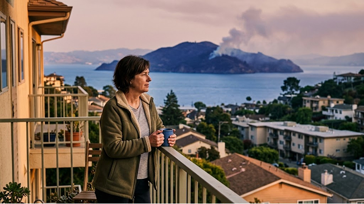
The Bay Area Air District smoke guidance is therefore relevant for residents who live near the Bay and expect to see smoke during the operation.
Weather Will Decide Whether The Burn Happens
The September 8 date is a target, not an unconditional start time.
California State Parks says the burn will proceed only when weather and air conditions are favorable for smoke dispersal. If those conditions are not suitable, the operation can be postponed and rescheduled.
That flexibility is one of the most important differences between a prescribed burn and an ordinary construction or maintenance project.
Fire managers need conditions that allow the vegetation to burn as planned while keeping smoke from settling heavily over nearby communities. Wind speed, wind direction, humidity, temperature and atmospheric stability can all affect how smoke moves.
The Bay Area Air District requires prescribed burns to be coordinated around smoke-management conditions. Its regulations also require agencies to use a smoke-management plan and obtain the necessary approvals before conducting qualifying burns.
For Angel Island, those requirements become particularly important because the island sits inside a dense metropolitan area.
San Francisco, Marin County and the East Bay are close enough that changing wind conditions can quickly determine which communities notice the smoke.
Fire Has A Much Longer History On Angel Island
Prescribed fire is not a completely new management concept for Angel Island.
California State Parks’ historical material notes that Coast Miwok people used prescribed fire as part of their stewardship of the island, including practices that encouraged the growth of native oak trees and other vegetation. Modern park managers continue to use prescribed burning as part of vegetation management and wildfire-risk reduction.
That historical connection adds an important layer to the current operation.
The practice is not simply about removing vegetation. Fire has long influenced California ecosystems, and many landscapes evolved with recurring low-intensity burns. Modern prescribed fire attempts to reintroduce some of those ecological processes under controlled conditions while also addressing the fuel accumulation created by decades of fire suppression and changing land-management practices.
Angel Island’s current operation therefore sits at the intersection of wildfire preparation, habitat management and historical land stewardship.
The scale is also significant. Burning as much as 260 acres on a 740-acre island means crews will be treating a substantial landscape rather than conducting a small demonstration burn.
What Visitors Should Expect During A Burn Day
Anyone visiting Angel Island during the operation should expect a different park experience.
Fire engines, personnel and equipment will be operating near active treatment areas. Temporary closures can appear with limited notice, and visitors may be redirected around portions of the trail network.
State Parks is asking visitors to follow closure signs and directions from park staff and fire personnel. The agency also recommends caution when recreating near prescribed-fire operations because of vehicles, equipment and active fire crews.
A practical visit plan should account for several possibilities:
- Check the Angel Island State Park status before leaving for the ferry.
- Expect portions of the Ida and Sunset trails to be unavailable.
- Do not cross barricades or enter closed roads and trails.
- Be prepared for smoke and changing visibility.
- Follow instructions from State Parks, CAL FIRE and Marin County firefighters.
The park’s normal recreation opportunities remain substantial, but visitors should avoid planning a trip around a specific trail or Mount Livermore summit access without confirming conditions on the day of the visit.
For those seeking another California destination after recent wildfire-related closures, the Big Sur tourism disruption story offers a useful comparison: access restrictions can change the experience of a destination even when the larger recreational landscape remains open.
The Burn Is Part Of A Larger California Wildfire Strategy
The Angel Island project also reflects a larger change in California’s approach to wildfire preparedness.
For decades, fire suppression limited the frequency of natural and human-managed burns across many California landscapes. That allowed vegetation and other fuels to accumulate in places where low-intensity fire historically played a role in ecosystem cycles.
Prescribed burning does not eliminate wildfire risk. It can, however, reduce the amount of available fuel and alter how a future fire moves through treated vegetation.
The Bay Area Air District describes prescribed burns as one tool for reducing fuel loads and lowering the potential for large catastrophic wildfires, which can create much greater and longer-lasting air-quality impacts than controlled burns.
For Angel Island, the calculation also involves the island’s proximity to millions of people.
A future wildfire would occur without the carefully selected weather window, staffing plan and containment resources that accompany a prescribed burn. The current operation gives fire managers an opportunity to work with the landscape under controlled circumstances rather than responding after ignition has already escaped.
That is especially important on an island where evacuation and firefighting logistics are different from those on the mainland.
Why The 260-Acre Project Matters Beyond Angel Island
Angel Island is a destination, but it is also a highly visible example of how California is redefining park management in an era of greater wildfire risk.
The island can be seen from numerous Bay Area communities. Its smoke will therefore turn a land-management operation into a highly visible public event, giving residents an opportunity to see prescribed fire in action rather than encountering wildfire smoke without warning.
The project also demonstrates why access to California parks can change even when no wildfire is burning.
This week, the restrictions are planned and temporary. The purpose is to reduce future risk, improve habitat and manage vegetation before uncontrolled fire creates a much more disruptive situation.
For visitors, that means the best approach is simple: check the latest park status before traveling, expect temporary restrictions and treat smoke as a planned part of the operation rather than automatically assuming an emergency.
The Angel Island State Park visitor information will remain the key source for current access conditions as the operation develops.
The prescribed burn could begin Tuesday, September 8, but the exact schedule will depend on the same environmental conditions that make controlled fire possible. For a park surrounded by one of America’s most densely populated metropolitan areas, that careful timing is the point.
Angel Island will burn this week because officials are trying to make sure it does not burn under circumstances they cannot control later.