

California’s late-October king tides offered coastal communities an unusually serious warning ahead of the 2026–27 winter season. Floodwater reached streets, homes, businesses, and sections of Pacific Coast Highway as elevated ocean levels combined with exceptionally high astronomical tides. In San Pedro, a tide gauge recorded 8.19 feet on October 27, the highest measurement since records began there in November 1923.
The flooding affected communities from San Diego County to Santa Barbara, with Newport Beach, Huntington Beach, Long Beach, and other coastal areas reporting unusually high water. The situation drew attention from local governments, transportation agencies, and coastal scientists because the seasonal cycle of exceptionally high tides has not yet reached its winter peak.
The concern extends beyond a few days of flooded streets. Warmer Pacific waters, an approaching period of stronger seasonal tides, and the possibility of winter storms could place additional pressure on California’s low-lying neighborhoods and coastal infrastructure. For residents and visitors, the latest flooding is a reminder that familiar waterfront locations can become hazardous even when skies are clear.
Record-Setting Tides Flood Southern California Communities
The late-October flooding developed as exceptionally high tides moved along the Southern California coastline. Newport Beach experienced widespread water intrusion around the Balboa Peninsula, where streets and waterfront properties were affected. Sunset Beach in Huntington Beach also experienced flooding, prompting the closure of part of Pacific Coast Highway.
Long Beach faced additional high-water impacts, while coastal areas in San Diego County and Santa Barbara recorded unusually elevated tide levels. The National Weather Service reported record or near-record conditions at several monitoring locations.
San Pedro’s tide gauge reached 8.19 feet on October 27, surpassing previous measurements in a record that extends back to 1923. Santa Barbara also recorded a high-water level of 8.04 feet on October 27, according to reporting by the Los Angeles Times. These measurements describe water levels relative to the stations’ tidal reference points, rather than the depth of flooding on nearby streets.
The scale of the event became especially visible in Newport Beach. Residents and businesses in low-lying parts of the Balboa Peninsula faced water moving beyond normal waterfront boundaries. City spokesperson Georgia Rios said approximately 25,000 sandbags were distributed over the weekend as residents prepared for the anticipated high tides.
The preparations helped limit the extent of damage, although flooding still affected vulnerable locations. The combination of record water levels and local response efforts showed how much advance preparation can matter when coastal communities receive warnings before a high-water event.
The Los Angeles Times reported on the record-setting tides and coastal flooding, documenting impacts across the region and concerns about additional flooding later in the season.
Why Ocean Levels Rose Beyond Normal Tide Predictions
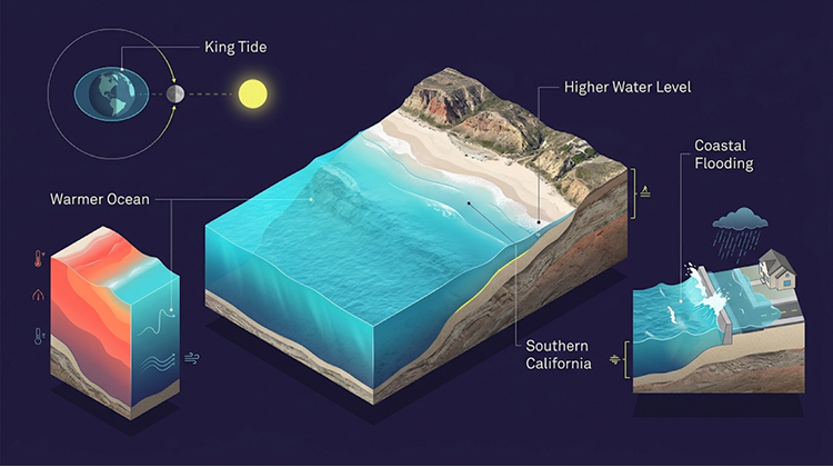
King tides are exceptionally high tides that occur naturally when the gravitational effects of the sun, moon, and Earth align. They are predictable astronomical events, not a separate type of storm or a sign that a coastal disaster is inevitable.
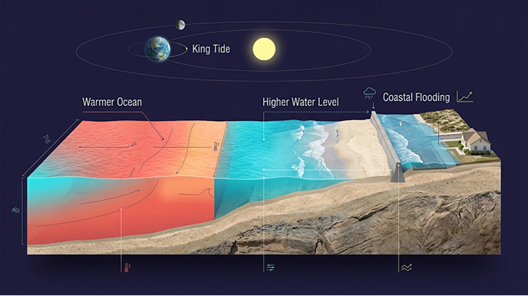
Their effects become more serious when the normal tidal cycle coincides with other conditions that raise the ocean’s starting level. That distinction helps explain why California experienced such unusual flooding in late October.
One factor is the unusually warm water associated with the current Pacific climate pattern. As seawater warms, it expands and occupies more space. This process, known as thermal expansion, can raise ocean levels without requiring additional water to enter the ocean.
A second factor is a Kelvin wave, a large-scale ocean disturbance that can move warm water and temporarily raise sea levels along a coastline. In October, this elevated water combined with the astronomical high tides, allowing seawater to reach farther inland than standard tide predictions would suggest.
Newport Beach officials reported that recent observed water levels had been approximately 15 to 22 inches above predicted astronomical tides. The city explained that this difference can determine whether water remains below a seawall or spills into streets, garages, and homes.
The city’s public information also warns that actual water levels depend on several changing conditions, including ocean temperature, atmospheric pressure, wind, and waves. Its illustrative high-water scenarios should therefore not be treated as official forecasts.
The City of Newport Beach’s coastal flood preparedness information explains how warmer ocean conditions and unusually high tides can increase flood exposure around the Peninsula, Balboa Island, and other low-lying neighborhoods.
El Niño Could Add Pressure During the Winter Tide Season
The late-October flooding occurred as California prepares for a potentially strong El Niño winter. El Niño influences ocean temperatures, atmospheric circulation, rainfall patterns, and storm activity across the Pacific. Its effects vary by region and season, so it does not guarantee a particular amount of rain or a specific number of coastal storms.
However, the combination of warmer ocean water, elevated sea levels, high tides, and powerful winter surf can increase coastal flood risks.
California officials are particularly concerned about the possibility of storms arriving during periods of exceptionally high tides. Heavy rainfall can overwhelm drainage systems, while large waves can push water over beaches, seawalls, and other coastal barriers. In locations with limited elevation, these conditions can compound one another.
The County of San Mateo warned residents that ocean levels were running approximately 1 to 2 feet higher than typical tide-table expectations under the conditions described in its October 20 advisory. The county also highlighted the potential for low-lying streets, trails, and parking areas to flood even on sunny days.
That warning matters beyond Southern California. Coastal communities around San Francisco Bay, Monterey Bay, and the broader Northern California shoreline also face exposure to high-water events, although local geography and tide patterns determine the specific impacts.
The National Weather Service and local authorities will continue monitoring coastal conditions as the winter season develops. Residents should avoid treating a calm weather forecast as proof that waterfront roads and walking paths are safe.
Newport Beach Activates Emergency Measures Ahead of High Water
Newport Beach became one of the most visible examples of local preparation during the October event. Before the highest tides arrived, the City Council declared a local emergency and activated its Emergency Operations Center.
The declaration allowed city departments to coordinate personnel and resources while monitoring conditions in vulnerable neighborhoods. Available response resources included pumps, sandbags, heavy equipment, and contractors.
The city also highlighted the vulnerability of locations around Newport Harbor, Balboa Island, Newport Island, the Balboa Peninsula, the Finley Tract, and West Newport. These areas include waterfront properties and streets where relatively small increases in water levels can create access problems.
Alongside the emergency response, Newport Beach approved a contract for the West Newport Beach Sand Replenishment Project. The project is expected to place approximately 100,000 cubic yards of sand along eroded beach areas between 36th and 62nd streets. The sand will be transported from the mouth of the Santa Ana River.
Beach replenishment can help restore eroded areas and provide additional protection against coastal flooding, although it does not eliminate the risk of future high-water events. Coastal protection requires continued monitoring, maintenance, and decisions about how communities manage vulnerable shorelines.
The city’s response also illustrates why local preparedness is essential. Statewide forecasts provide important context, but individual neighborhoods have different elevations, drainage systems, seawalls, and exposure to waves.
Residents can follow updates through the Newport Beach emergency and coastal preparedness information, including local advisories and guidance for waterfront properties.
Upcoming King Tide Dates Could Bring More Coastal Flooding
California’s king tide season continues through the winter, giving residents and local agencies additional opportunities to prepare for high-water conditions.
The California Coastal Commission has published the statewide king tide observation windows for the 2026–27 season:
| Period | Statewide king tide dates |
|---|---|
| November 2026 | November 24–26 |
| December 2026 | December 23–25 |
| January 2027 | January 21–22 |
Northern California locations may also experience peak tides on adjacent dates, depending on local conditions and tide timing.
These dates identify the highest predicted astronomical tides selected for the California King Tides Project. They do not represent forecasts of flooding at every coastal location. Actual water levels can be higher or lower depending on ocean conditions, atmospheric pressure, wind, waves, and storms.
The California Coastal Commission encourages residents to photograph and document king tides through its statewide project. These observations help researchers and communities compare current shoreline conditions with future sea-level changes.
The project also provides a practical way for residents to recognize locations that may become vulnerable as sea levels rise. Photos of flooded trails, parking areas, beaches, and waterfront streets can contribute to a broader record of coastal change.
People interested in participating can consult the California King Tides Project for observation dates, safety guidance, and information about submitting photographs.
Coastal Roads, Beaches, and Visitor Access Face Additional Risks
High tides can disrupt more than residential neighborhoods. Roads, public parking areas, waterfront businesses, beaches, and recreational trails may all experience temporary closures or access restrictions.
The closure of part of Pacific Coast Highway near Sunset Beach during the October flooding demonstrated how quickly coastal water can affect a major transportation corridor. Even a temporary closure can disrupt local commutes, deliveries, beach visits, and access to nearby businesses.
For visitors, the risks can be less obvious. A beach may appear accessible from a parking area while waves are reaching farther inland than usual. Coastal paths can become slippery or inundated, and water moving across roads can conceal hazards beneath the surface.
People planning trips to California’s coastline should check local advisories before leaving and remain prepared to change their plans. The state’s coastal destinations remain popular during fall and winter, but visitors should account for tide conditions and temporary access restrictions.
The California destinations guide offers a starting point for exploring coastal communities and outdoor locations. During periods of elevated water, however, current local alerts and road conditions should take priority over ordinary travel plans.
Drivers should never attempt to cross flooded roads. Even shallow moving water can affect vehicle control, hide damaged pavement, or conceal deeper sections. Pedestrians and cyclists should also avoid walking or riding through floodwater.
What Residents Can Do Before the Next High Tide
The October flooding demonstrated the value of preparation before water reaches streets and properties. Residents in coastal neighborhoods can reduce avoidable risks by monitoring local forecasts, identifying vulnerable access routes, and securing outdoor items before high tides arrive.
Property owners in flood-prone locations should pay attention to local emergency instructions, drainage conditions, and the availability of sandbags or other protective materials. Those living near waterfront areas should also consider where vehicles can be moved if streets become inaccessible.
Travelers should check the National Weather Service, local city announcements, and Caltrans road information before visiting coastal areas during high-tide periods. Temporary restrictions can change as water levels rise or fall, so checking conditions close to departure is useful.
The California Coastal Commission also advises people to observe king tides from safe locations. Visitors should avoid exposed rocks, seawalls, flooded walkways, and areas where large waves can reach unexpectedly. Photographing the ocean is never worth standing in a dangerous location.
Residents can use the National Weather Service for coastal flood advisories and local forecasts, while the Caltrans road information service provides updates about highway closures and travel restrictions.
California’s October Flooding Offers an Early Warning for Winter
The record-setting tides of late October showed how quickly elevated ocean levels can affect California’s coastal communities. From Newport Beach’s Balboa Peninsula to Huntington Beach, Long Beach, San Pedro, and Santa Barbara, the flooding exposed vulnerabilities that become more serious when high tides overlap with warmer ocean conditions and winter storms.
The next major king tide periods are already identified, but their effects will depend on the conditions present when they arrive. A high astronomical tide does not automatically produce a flood. The greatest concern comes when elevated background sea levels, strong surf, rainfall, and coastal storms occur together.
For California’s residents, transportation agencies, and visitors, the coming months will require attention to local warnings and changing shoreline conditions. The October event provided a clear example of why coastal preparedness must begin before the next storm reaches the shoreline.