

Southern California is facing another unusual coastal weather threat just days after a historic October heat wave pushed temperatures across the region into triple digits. Hurricane Rachel, now moving west-northwest across the eastern Pacific, is expected to weaken substantially before approaching the Baja California and Southern California region. Even so, forecasters are watching the storm because its projected turn toward the northeast could bring tropical moisture, powerful ocean swell, dangerous surf and periods of heavy rain to Southern California this weekend.
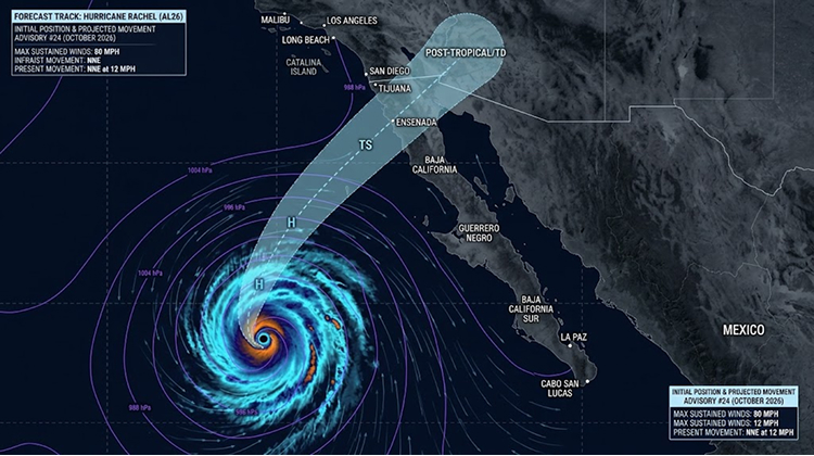
The situation is different from a conventional hurricane landfall. The National Hurricane Center said Wednesday, October 7, that Rachel was about 775 miles west of the southern tip of Baja California with maximum sustained winds of 80 mph. The system was moving west-northwest at about 7 mph, with a sharp turn toward the northeast expected by the end of the week.
That change in direction is what makes Rachel relevant to California travelers. The storm does not need to arrive as a hurricane to disrupt coastal plans. Large swells, rip currents, coastal flooding, beach erosion, rain and changing road conditions can affect visitors well before the center of a tropical system approaches land.
Rachel Is Turning Toward Southern California
Rachel developed in the eastern Pacific at the end of September and became a major hurricane during its early October intensification. On October 1, the National Hurricane Center reported maximum sustained winds of 105 mph as Rachel moved near the southern tip of Baja California.
The storm later weakened while traveling over progressively cooler water and encountering increasing wind shear. By October 7, Rachel had maximum sustained winds of 80 mph and a minimum central pressure of 979 millibars. The National Hurricane Center expects gradual to steady weakening during the next several days.
The forecast track, however, remains significant.
The latest National Hurricane Center forecast takes Rachel north and east after it slows over the Pacific. By Friday into Saturday, the system is expected to transition into a post-tropical cyclone. The current forecast places the system near 31.0°N, 116.8°W on Saturday and then farther inland by Sunday, although forecast uncertainty remains substantial.
That projected path places the storm’s broader weather influence close enough to Southern California to matter for weekend travel.
Travelers can monitor the National Hurricane Center for changes to Rachel’s official forecast rather than relying on social media storm maps or older forecasts.
Dangerous Surf Is Already Affecting California Beaches
The coastal effects are arriving before Rachel itself.
The National Weather Service in San Diego has a Beach Hazards Statement in effect through Friday evening for the San Diego and Orange County coastal areas. As of October 7, forecasters expected surf of 3 to 6 feet, dangerous rip currents and minor coastal flooding around high tides. High tides were forecast to reach approximately 6.5 to 7 feet during morning and evening periods.
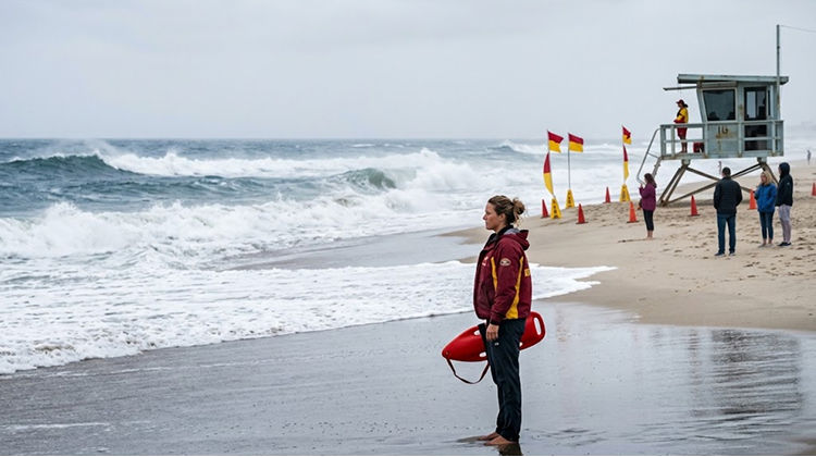
The combination matters because elevated surf arriving during high tide can push water farther onto beaches, parking areas, boardwalks and low-lying coastal roads.
The National Weather Service specifically warned that minor coastal erosion is possible and that flooding could affect beach parking lots, boardwalks and roads. Isolated road closures are possible if water reaches vulnerable areas.
For visitors, that creates a very different travel experience from a normal autumn beach day. A location can remain sunny and warm while ocean conditions become dangerous.
That distinction is particularly important after Southern California’s extraordinary early-October heat. Record temperatures have encouraged residents and visitors to seek relief near the coast, precisely when the ocean is becoming less suitable for swimming, surfing and recreational boating.
Malibu, Long Beach and Catalina Face Different Risks
Southern California’s coastline is not exposed to Rachel in exactly the same way.
The National Weather Service has identified several locations along the Los Angeles-area coast where elevated surf and coastal flooding could produce more noticeable impacts. Malibu, Long Beach, Catalina Island and other low-lying coastal locations have particular exposure to high water, large waves and erosion.
Long Beach is especially relevant because sections of the coastline include relatively low-lying infrastructure and heavily used public spaces. The National Weather Service has highlighted the Alamitos Peninsula among the locations of greatest concern for coastal flooding.
Catalina Island also faces a different combination of risks because visitors and transportation depend heavily on marine conditions. Rougher seas can affect recreational boating, harbor activity and ferry travel even if the storm center remains hundreds of miles away.
Malibu presents another challenge. Its narrow coastal corridor combines beaches, roads, homes and recreational areas in a landscape already exposed to erosion and wave action. Stronger-than-normal surf can therefore become a transportation issue as well as a beach-safety issue.
The California Coastal Commission has repeatedly addressed the state’s long-running challenges involving shoreline erosion, public beach access and coastal infrastructure. Rachel arrives at a time when those issues are already receiving greater attention because of the state’s expected strong El Niño winter.
Rain Could Follow an Extreme October Heat Wave
Rachel’s timing is also significant because Southern California is coming out of an exceptional heat event.
Downtown Los Angeles reached 104°F on October 5, while several other Southern California locations also established October records. The National Weather Service issued prolonged extreme heat warnings as temperatures remained far above normal.
That pattern is expected to break sharply as cooler air and moisture move into the region.
The National Weather Service’s San Diego office said Wednesday that a low-pressure system approaching from the southwest, combined with tropical moisture, should bring showers from late Saturday night through Sunday night, with additional chances continuing into the following week. The forecast included a 45% to 55% chance of at least 0.10 inches of rain through Sunday night near the broader region, while the chances of heavier precipitation increase in the mountains.
Those numbers do not mean every Southern California destination will receive heavy rainfall. They do indicate a substantial change from the dry, extreme-heat conditions that dominated the first week of October.
For travelers, the transition could be abrupt: beach heat early in the week followed by cooler temperatures, cloud cover, rain and hazardous ocean conditions by the weekend.
That is why visitors planning California outdoor adventures should check forecasts again immediately before departure rather than relying on conditions observed earlier in the week.
Rachel Is Not Expected To Reach California as a Hurricane
The most important distinction for travelers is that Rachel is not currently expected to remain a hurricane as it approaches the California region.
The National Hurricane Center’s October 7 forecast calls for Rachel to weaken as it moves over cooler ocean water and encounters stronger wind shear. The agency projects the system to become post-tropical around Saturday.
That does not eliminate the threat.
Tropical systems can retain large areas of moisture and strong winds after losing their tropical characteristics. A post-tropical system can also interact with a separate upper-level weather pattern and produce substantial rainfall or wind over land.
Rachel’s forecast discussion specifically notes that tropical-storm-force winds could potentially persist later in the forecast period despite the expected transition to a post-tropical cyclone.
The practical message for travelers is simple: the storm’s category is less important than the local hazards it produces.
A weakened tropical system can still close beaches, create dangerous surf, flood low-lying roads and disrupt outdoor events.
Coastal Travel Plans May Need Flexibility
Visitors planning Southern California trips for the weekend should pay particular attention to activities that depend on calm ocean conditions.
Surfing, swimming, kayaking, paddleboarding, small-boat excursions and rock fishing carry greater risk when rip currents and wave heights increase. The National Weather Service is advising people to remain out of the water during hazardous conditions and to avoid driving through flooded areas or around barricades.
Boating operators face another set of concerns. Large swell can create difficult conditions near harbor entrances and exposed coastal waters even when winds on land remain relatively moderate.
Beach visitors should also avoid assuming that a familiar stretch of sand is safe simply because there is no rain. A distant tropical cyclone can generate long-period swell that reaches California ahead of the main weather system.
For families and tourists, the safest approach is to build flexibility into coastal itineraries. Museums, inland attractions, restaurants and other non-ocean-dependent activities can provide alternatives if beach conditions deteriorate.
The same principle applies to road trips. Coastal Highway 1 and other scenic routes can be affected by flooding, falling debris, erosion or temporary closures during periods of heavy rain and high surf.
A Larger Warning Before California’s El Niño Winter
Rachel is arriving against a much larger backdrop.
California is already preparing for a potentially historic El Niño winter. Forecasts indicate unusually warm Pacific waters could contribute to stronger storms, higher coastal water levels, atmospheric rivers and increased erosion risks during the coming months.
That means Rachel is more than an isolated October weather event for California’s tourism industry.
The state is entering a season in which coastal communities may have to deal with repeated combinations of high tides, large waves, heavy rain and elevated sea levels. Infrastructure that survives one event can face additional pressure when another arrives days or weeks later.
For visitors, this changes the way seasonal travel should be planned. Fall and winter trips along the California coast remain possible, but weather conditions may become more variable than travelers expect from traditional tourism calendars.
The lesson from Rachel is not that California’s coast is about to experience a hurricane landfall. The current forecast does not support that conclusion. Instead, Rachel demonstrates how a storm hundreds of miles offshore can still influence beach safety, transportation and recreational conditions.
California Travelers Should Watch The Forecast, Not The Storm Name
Rachel’s eventual impact will depend heavily on its track, timing, strength and interaction with the larger weather pattern over the western United States.
As of October 7, the National Hurricane Center has no coastal watches or warnings in effect for California, and its official forecast calls for weakening as Rachel moves northeast later in the week.
At the same time, Southern California already has active coastal hazards, including dangerous rip currents, elevated surf, minor coastal flooding and erosion concerns. The National Weather Service is also forecasting a significant transition toward cooler and wetter conditions late Saturday and Sunday.
For travelers, that combination is enough to justify caution.
The best strategy is to check the National Weather Service and National Hurricane Center immediately before heading to the coast, pay attention to local beach advisories, avoid entering the ocean when rip-current warnings are active, and keep alternative plans available for outdoor activities.
Rachel may ultimately pass California with limited effects. But its arrival during an unusually hot October, an active Pacific hurricane season and the approach of a potentially historic El Niño winter makes it a useful warning for anyone planning time along the state’s coastline: California’s next major travel disruption may come from the ocean even when the storm itself never reaches the beach.