

Tamarack State Beach in Carlsbad has become one of the clearest examples of how quickly Southern California’s coastline can change when powerful waves, high tides and an unusually energetic Pacific converge. In early August 2026, strong swells associated with Hurricane Genevieve stripped away much of the sand that had accumulated along the beach, exposing riprap, destabilizing portions of the parking-lot protection system and forcing the closure of at least part of the main Tamarack parking area. Recent reporting indicates that the beach lost most of its sand in less than two weeks.
The episode is especially significant because Tamarack was not an untouched stretch of shoreline. The beach had received approximately 400,000 cubic yards of sand dredged from Agua Hedionda Lagoon in early 2025, part of a broader effort to maintain the recreational beach. The rapid removal of that material has renewed questions about how California should protect public beaches and the infrastructure built immediately behind them.
For Carlsbad, the issue extends beyond whether the beach looks different this summer. Tamarack sits within a heavily used coastal corridor where parking, lifeguard operations, pedestrian access, roads and recreational facilities depend on a narrow strip of sand remaining between the Pacific Ocean and developed land.
Tamarack’s Sand Disappeared With Unusual Speed
Beach erosion is a normal part of the Southern California coastal cycle. Sand moves offshore during energetic wave conditions and can later return during calmer periods. What made the Tamarack event particularly striking was the speed and scale of the transformation.
Powerful swells generated by Hurricane Genevieve battered the coast during the first part of August. According to reporting from SFGATE, the waves removed so much sand that Tamarack changed from a broad sandy beach into a much rockier shoreline within approximately two weeks. The loss exposed protective riprap that had previously been partly buried beneath the beach.
At least 35 parking spaces were affected, while several lifeguard towers had to be repositioned. The boulders used to protect the parking lot also shifted as the sand surrounding them disappeared. California State Parks said it was working with coastal engineers to evaluate ways to keep the parking lot open while minimizing additional damage.
| Tamarack Impact | Reported Change |
|---|---|
| Sand | Large-scale loss during August 2026 |
| Parking | At least 35 spaces affected |
| Riprap | Sections shifted and became exposed |
| Lifeguard facilities | Multiple towers repositioned |
| Recent nourishment | Approximately 400,000 cubic yards added in 2025 |
| Response | California State Parks working with coastal engineers |
The situation illustrates a fundamental characteristic of beaches: the sand that makes a coastal park attractive to visitors is also part of the physical system absorbing wave energy.
When that sand disappears, infrastructure can suddenly become much more exposed.
The Parking Lot Became A Coastal Engineering Problem
The most visible consequence at Tamarack is not simply the disappearance of sand. It is the changing relationship between the ocean and the infrastructure immediately behind it.
The parking lot was protected by riprap—large rocks placed along the shoreline to reduce the direct impact of waves on developed property. Under normal conditions, a substantial layer of beach sand can sit in front of that protection. During extreme wave conditions, however, sand can be rapidly transported offshore, exposing the rock structure and allowing waves to reach the coastal edge with greater force.
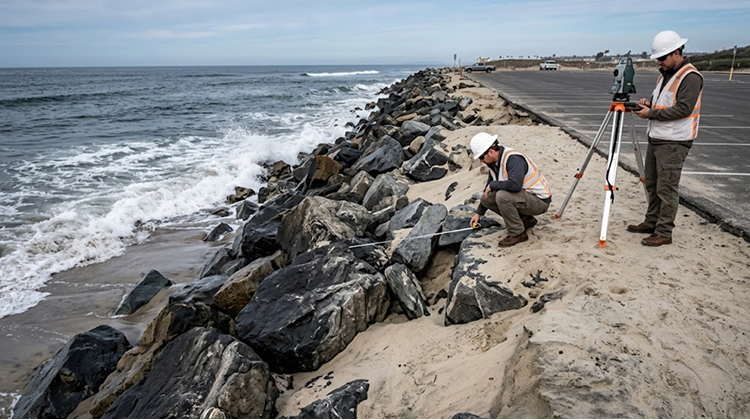
That is what has made Tamarack such an important case study in 2026.
The question is no longer just how much sand the beach has lost. It is whether the existing protective system can continue performing as intended when the sand that surrounds it repeatedly moves away.
Recent photographs show the riprap in unstable positions and sections of the parking area becoming increasingly vulnerable. State officials are therefore examining engineering options rather than treating the event as a routine beach-maintenance issue.
This distinction matters because hard infrastructure can protect a road or parking lot in one location while changing how waves and sand behave elsewhere.
A seawall, revetment, jetty or riprap system can become part of a much larger sediment-management equation.
Carlsbad Had Already Invested Heavily In Beach Nourishment
Tamarack’s current appearance is also significant because the beach had recently undergone substantial nourishment.
In early 2025, approximately 400,000 cubic yards of sand from Agua Hedionda Lagoon were placed along the Carlsbad shoreline. The purpose was to replenish the beach and maintain recreational space.
That investment makes the rapid loss of sand particularly consequential.
Beach nourishment is widely used along developed coastlines because it can restore recreational beaches without immediately replacing them with permanent hard structures. But nourishment does not permanently lock sand into place. Waves, tides and currents can redistribute it.
UC Santa Cruz coastal scientist Gary Griggs has described nourishment as a short-term response rather than a permanent solution to the underlying dynamics of an eroding coastline.
That observation does not mean nourishment has no value. A wider beach can provide recreational benefits and temporarily increase the distance between waves and infrastructure. The issue is how long that benefit lasts and what happens when an extreme event removes the material.
Tamarack’s experience provides a real-world example of that tension.
Hurricane Genevieve Was The Immediate Trigger
The August erosion should not be attributed to a single factor without qualification.
The immediate catalyst was the powerful wave activity generated by Hurricane Genevieve, which developed in the eastern Pacific and produced unusually strong swells that traveled toward Southern California. Those waves arrived alongside high tides and existing coastal conditions that left portions of the shoreline vulnerable.
The hurricane itself did not make direct landfall in Carlsbad.
Instead, its influence was transmitted through the ocean.
That distinction is important because California’s coastline can experience substantial impacts from Pacific storms even when the storm center remains far offshore. Long-period swells can travel considerable distances, arriving with enough energy to reshape beaches and affect infrastructure.
The 2026 episode is therefore a useful reminder that coastal risk is not determined solely by whether a tropical system crosses California.
Wave direction, period, tide level, beach profile and the amount of available sand all influence the eventual outcome.
El Niño Could Make The Coming Winter More Difficult
The Tamarack event has occurred before the strongest impacts of the developing 2026–27 El Niño are expected.
NOAA’s California Current assessment, updated August 26, said El Niño conditions were present and expected to strengthen during the Northern Hemisphere winter. Forecast models indicated more than a 90% chance of a very strong El Niño during November 2026 through January 2027, potentially placing the event among the strongest in the historical record.
That forecast matters because El Niño can influence both ocean temperatures and coastal conditions.
The California Coastal Commission notes that the 2015–16 El Niño produced record coastal erosion at many California beaches, with Central California experiencing average erosion of approximately 150 feet in some areas. The agency also cites research showing that extreme El Niño events can substantially increase California coastal erosion through changes in wave energy, direction and sea level.
For Carlsbad, the concern is not that Tamarack will necessarily experience another identical erosion event.
The concern is that the beach could enter the winter with less sand available to absorb wave energy.
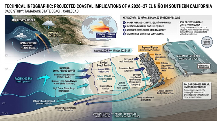
That creates a potentially unfavorable starting point if stronger winter storms and higher water levels arrive.
California’s Coastal Infrastructure Is Already Showing The Strain
Tamarack is part of a much broader Southern California pattern.
In August, erosion also affected Point Dume in Malibu, where approximately 60 feet of sand disappeared near a road providing access to a parking lot. Newport Beach experienced enough sand loss for decades-old infrastructure to become exposed. Laguna Beach also saw lifeguard infrastructure left with dramatically reduced sand around it.
These events are occurring across different communities and under different local conditions.
What connects them is the increasing vulnerability of infrastructure built close to the shoreline.
The modern California coast contains roads, parking areas, bathrooms, pedestrian paths, utilities, lifeguard facilities and public amenities that were constructed based on historical assumptions about beach width and coastal stability.
When the beach profile changes rapidly, those assumptions can become outdated almost overnight.
The California Coastal Commission’s own analysis of El Niño demonstrates why this matters. Historical El Niño events have produced significant damage to public recreational facilities, while the agency warns that climate-related changes could increase the intensity of future extreme events.
Carlsbad Is Already Planning For Longer-Term Coastal Risk
The Tamarack erosion episode is unfolding alongside a broader planning effort in Carlsbad.
The city has completed a Sea Level Rise Vulnerability Assessment examining potential impacts through 2050 and 2100. The assessment covers beaches, state parks, public access points, streets, trails, utilities, lagoons and other critical infrastructure.
The city’s analysis identifies several potential effects of rising sea levels, including narrower beaches, temporary flooding during severe storms and high tides, and greater erosion of coastal bluffs.
That planning framework changes the way Tamarack’s current problem can be understood.
The August erosion is an immediate event, but the infrastructure question is longer term.
If the frequency or severity of damaging wave events increases, Carlsbad will need to determine which assets should be protected, redesigned, relocated or allowed to adapt to changing coastal conditions.
That is a much more complicated decision than simply replacing lost sand.
Beach Access Infrastructure Faces Its Own Challenges
The vulnerability is not limited to the Tamarack parking lot.
Carlsbad is already undertaking projects to repair and improve beach access infrastructure along Carlsbad Boulevard. The city says some older stairways have experienced concrete deterioration, exposed rebar, corrosion and soil erosion around foundations.
The city has also been working on sidewalk and stairway improvements near the coastal corridor, with additional work planned for 2026.
That creates an important overlap between ordinary infrastructure maintenance and climate-related coastal adaptation.
A stairway may have been built decades ago under a different set of shoreline conditions. A sidewalk can remain structurally sound while the land beneath or immediately adjacent to it becomes more vulnerable. A parking lot can function normally until a single erosion event removes the sand buffer protecting its edge.
The result is that coastal infrastructure planning increasingly has to consider the behavior of the beach itself.
The Real Question Is What Happens After The Sand Moves
One of the most revealing aspects of Tamarack’s transformation is that the exposed shoreline may look alarming to people accustomed to seeing a much wider sandy beach, even though portions of the area resemble historical configurations.
Historical photographs and repeat photography show that Tamarack’s shoreline has changed substantially over the decades. Recent documentation comparing older imagery with 2026 photographs shows how dramatically the beach profile can differ depending on nourishment, erosion and coastal engineering.
That history complicates the idea that every visible loss of sand represents permanent disappearance.
Some sand will naturally move back.
The more important issue is whether enough sand returns, how quickly it returns and whether infrastructure remains safe while the beach profile changes.
For a public beach, those questions have direct operational consequences.
A parking lot cannot wait indefinitely for natural sediment recovery if its protective rock system becomes unstable. Lifeguard towers have to remain positioned safely. Visitors need reliable access. Coastal engineers need to determine whether emergency intervention is necessary.
Tamarack Could Become A Test Case For Southern California
Tamarack State Beach is now part of a much larger coastal experiment taking place across California.
Communities are trying to preserve beaches as public recreational spaces while also protecting roads, parking lots and public facilities from a coastline that naturally moves and can change rapidly during extreme events.
The city of Carlsbad’s broader vulnerability assessment already recognizes that sea-level rise and coastal hazards will affect both natural and built environments.
The coming months could provide an important test of those planning assumptions.
NOAA’s current outlook points toward a potentially very strong El Niño during the winter. At the same time, the coast has already experienced major sand losses from summer swells.
That combination gives coastal engineers a difficult starting point.
If Tamarack’s sand naturally returns, some of the immediate pressure on the parking lot and riprap could ease. If additional powerful swells arrive before substantial recovery occurs, however, the exposed infrastructure could face another round of wave attack.
For visitors following Carlsbad’s coastline, the changes will be visible at the beach itself. For city planners and California State Parks, the more important question is hidden beneath the surface: how much protection can a beach provide when its sand is no longer where the infrastructure was designed to expect it?
The answer will influence decisions about nourishment, riprap, access, parking, coastal engineering and public spending far beyond Tamarack.
Carlsbad’s experience also reinforces the importance of treating beaches as dynamic systems rather than permanent strips of sand. The shoreline can move faster than infrastructure budgets, construction schedules and regulatory processes.
As California prepares for a potentially powerful El Niño winter, Tamarack State Beach offers an unusually clear warning: the next major coastal challenge may not begin with a damaged building or collapsed road. It may begin when the sand that protects them disappears.