

Tropical Storm Rachel has left Southern California with a very different coastline than it had just weeks ago.
What began as a tropical system approaching the region became the latest and most visible test of Southern California’s increasingly vulnerable shoreline. Powerful surf, unusually high tides and already-eroded beaches combined to damage homes, undermine coastal infrastructure and force temporary closures at some of the state’s most recognizable beaches and parks.
On the Long Beach Peninsula, waves damaged the historic boardwalk and affected homes along Seaside Walk. In Orange County, residents in Capistrano Beach watched the ocean erode sand beneath structures that had already been damaged by earlier storms. Newport Beach crews built large sand berms to defend the Balboa Peninsula from additional flooding.
Meanwhile, California State Parks temporarily closed portions of Crystal Cove State Park and San Onofre State Beach after Rachel’s surf caused significant erosion and infrastructure damage. At Crystal Cove, occupants of 26 historic cottages were evacuated, while San Onofre suffered damage to its shoreline, roadway, parking areas and water infrastructure.
Rachel was not simply another storm passing along the Pacific coast. It arrived after previous September storms had already removed protective sand and weakened vulnerable sections of shoreline.
That sequence is now forcing California communities to confront a larger question: how much damage can the coast absorb before ordinary tourism infrastructure becomes increasingly difficult to maintain?
Long Beach’s Historic Waterfront Takes Another Hit
The Long Beach Peninsula became one of the clearest examples of Rachel’s impact.
The city’s historic boardwalk and protective coastal structures had already been damaged by earlier storms. Rachel’s powerful surf accelerated the deterioration, with portions of the boardwalk collapsing further between 64th and 65th Place on Seaside Walk.
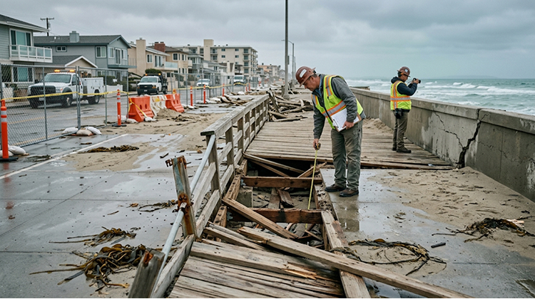
The damage was not limited to public infrastructure.
By Monday, October 12, inspectors had red-tagged eight buildings affecting 13 individual addresses along the peninsula, while another building had been yellow-tagged. A red tag means a building is considered unsafe to enter, while a yellow tag restricts its use.
The city’s response included sandbags, emergency repairs and sand berms intended to reduce the amount of wave energy reaching the shoreline.
Long Beach officials have also been preparing longer-term measures. The city has estimated permanent repairs to the damaged bulkhead and boardwalk could cost between $1.5 million and $3.6 million, with emergency funds being used for the work. A project scheduled to begin the week of October 19 is expected to move sand from the Alamitos Bay Entrance Channel to widen the beach by approximately 200 feet.
That is a significant investment for a coastline that may face additional storms before winter ends.
Long Beach Mayor Rex Richardson has described the situation as a broader coastal-resilience challenge, noting that three major storm systems have affected the region within roughly six weeks.
For visitors, the consequences are immediate. Vehicle access to portions of the peninsula has been restricted, emergency crews are operating near damaged structures, and some areas remain unsafe for casual sightseeing.
The Long Beach waterfront remains a destination, but Rachel has demonstrated how quickly the physical conditions surrounding a popular coastal attraction can change.
Capistrano Beach Is Losing More Than Sand
Further south, Dana Point’s Capistrano Beach has become one of the most dramatic examples of coastal erosion following Rachel.
On October 12, the City of Dana Point reported seven homes red-tagged and 13 yellow-tagged, while two homes had already been demolished and another was scheduled for demolition. Several properties had been damaged during an earlier storm before Rachel arrived.
The problem is not simply that waves are striking the buildings.
The waves are removing the sand that supports structures built directly along the shoreline. As that material disappears, foundations and slabs can become exposed and vulnerable to movement.
Residents told ABC7 that some homes deteriorated extraordinarily quickly as water eroded the sand underneath them. Sidewalk sections were also buckling and falling toward the ocean.
That makes Capistrano Beach an important case study for California’s coastal tourism future.
A beach can remain visually attractive while its underlying infrastructure becomes increasingly unstable. Roads, sidewalks, parking areas, utilities and buildings all depend on a shoreline that can change dramatically during a series of large-wave events.
For travelers, this is one reason California’s coastal destinations should not be judged solely by whether a beach appears open on a map.
Current conditions can change from one tide cycle to the next.
Crystal Cove’s Historic Cottages Face New Pressure
Crystal Cove State Park illustrates a different dimension of Rachel’s impact because the threatened infrastructure is also part of California’s cultural history.
The park’s Historic District contains 46 vintage rustic cottages originally built during the 1930s and 1940s. The buildings sit directly beside one of Orange County’s most recognizable stretches of coastline.
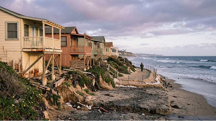
California State Parks temporarily closed portions of the Historic District beach after high surf and strong tides caused significant erosion and damage to coastal infrastructure. As a precaution, occupants of 26 cottages in vulnerable areas were evacuated, and reservations were canceled through at least October 13.
State Parks crews installed temporary sand-filled barriers to absorb wave energy and protect threatened facilities and historic resources.
The latest park information indicates that Crystal Cove is open with restrictions, while the Historic District continues to experience impacts from the swell event and high tides.
For California tourism, Crystal Cove is particularly important because it combines several visitor experiences in one location: beaches, tide pools, hiking, historic architecture, coastal scenery and overnight accommodations.
When erosion affects one part of that system, the impact extends beyond the immediate beach.
A closed access route can affect cottage reservations. Damaged utilities can affect overnight stays. Eroded coastal infrastructure can limit recreational access. Emergency construction can change the visitor experience even in areas that remain technically open.
Rachel therefore turned coastal erosion into a visitor-management issue at one of Orange County’s most recognizable state parks.
San Onofre’s Roads And Utilities Were Also Damaged
San Onofre State Beach experienced a different set of problems.
At Surf Beach, high surf and erosion damaged the shoreline, roadway, parking areas and utility infrastructure. California State Parks reported that a water main serving the beach restrooms was exposed and broken by the surf, leaving restroom facilities and water service unavailable.
Lower dirt parking lots were closed to vehicles, while portions of the upper paved parking areas were temporarily closed as crews worked on storm damage.
A threatened restroom building also required emergency removal.
The beach itself remained available for surfing, walking and bicycling outside designated work zones, but access restrictions were necessary where heavy equipment and repair crews were operating.
That distinction matters because San Onofre is not simply a sightseeing location. It is a major recreational destination used for surfing, camping, hiking, fishing, wildlife viewing and other outdoor activities.
When coastal infrastructure is damaged, the effects can spread across multiple types of recreation.
The California State Parks response also demonstrates why post-storm closures are not necessarily signs that an entire park has become inaccessible. Instead, specific facilities can be closed while other portions remain available under changing restrictions.
Visitors should therefore check individual park alerts before traveling rather than assuming conditions are uniform across a large coastal park.
Newport Beach Built A Temporary Defense
Newport Beach provides a contrasting example of a community that managed to prevent some of Rachel’s worst potential flooding.
Large waves and elevated tides pushed water toward the Balboa Peninsula, with flooding affecting streets and low-lying areas. City crews responded by constructing substantial sand berms along vulnerable sections of the peninsula.
By Monday, the berms had helped prevent additional significant flooding in the protected areas despite continued large surf.
The response demonstrates how quickly coastal communities can shift from normal tourism operations to emergency shoreline management.
Heavy equipment, excavators and bulldozers were used to move large quantities of sand while crews worked around high tides.
For visitors, that can produce an unusual landscape: beaches normally associated with recreation become temporary construction zones, while emergency crews work to protect homes, businesses and roads behind them.
Newport Beach’s experience also highlights the importance of having physical space available for emergency sand management.
The ability to build a berm depends on the existing beach profile, available sand and access for heavy machinery. As beaches lose sand during repeated storms, the options for temporary protection can become more limited.
Rachel Arrived After Earlier Storms Had Already Changed The Coast
One of the most important details in Rachel’s story is that the storm did not hit an untouched coastline.
Southern California had already experienced significant coastal impacts from earlier storms, including Hurricane Marie and Hurricane Polo. Those events removed sand and weakened portions of beaches and coastal defenses before Rachel arrived.
The Long Beach Fire Department described the damage to its boardwalk as cumulative, with the structure deteriorating across multiple storm events rather than failing because of one isolated wave.
That distinction changes the way California should evaluate storm damage.
A single storm can produce substantial erosion, but repeated events can prevent beaches from recovering between impacts.
Sand that normally serves as a natural buffer between waves and infrastructure may not return quickly enough.
Once that buffer is reduced, subsequent waves can reach structures with much greater force.
This is particularly significant heading into winter.
California’s coast is now entering the period when larger Pacific storms become more common, while forecasters are also watching the effects of a powerful El Niño.
El Niño Could Keep Coastal Pressure High
Rachel’s aftermath is occurring alongside a much larger ocean and climate pattern.
The 2026 Pacific hurricane season has already produced exceptionally strong activity east of the International Date Line. The Associated Press reported October 13 that accumulated cyclone energy, a measurement incorporating storm intensity and duration, had surpassed the previous record for the region set in 2018. Scientists have linked the unusual activity primarily to an exceptionally strong El Niño combined with unusually warm ocean waters.
For Southern California, the concern is not that every future storm will directly strike the coast.
The greater issue is the combination of factors that can raise coastal vulnerability: high tides, warm ocean water, large swells, previous erosion and additional winter storms.
The current situation has already demonstrated how those factors can interact.
Rachel weakened before reaching Southern California, eventually becoming post-tropical. Yet its remnants still contributed to heavy rain, gusty winds and coastal impacts across the region. The National Weather Service reported that Rachel was approximately 60 miles east-northeast of San Diego early Sunday, October 11, with maximum sustained winds of 50 mph.
The storm’s classification mattered less than the conditions it produced along the shoreline.
Coastal Parks May Need More Than Temporary Closures
The response to Rachel is likely to continue well after the storm itself has disappeared.
Emergency repairs can stabilize damaged roads, utilities and access points, but they do not necessarily solve the underlying erosion problem.
Crystal Cove’s temporary barriers, San Onofre’s emergency construction and Long Beach’s sand berms are immediate measures. Permanent solutions require decisions about how much infrastructure should be rebuilt, where it should be rebuilt and how much protection can realistically be maintained.
Those questions become harder when the same coastal areas face repeated storms.
California’s coastal parks are especially complicated because they must balance public access, habitat protection, historic preservation and infrastructure safety.
Crystal Cove illustrates the challenge particularly well. Protecting the historic cottages may require temporary barriers and emergency engineering, but the park also needs to preserve its natural shoreline and public beach access.
San Onofre faces similar tensions between recreational use and infrastructure vulnerability.
The goal is therefore not simply to rebuild everything exactly as it was.
Rachel has demonstrated that some coastal infrastructure may need to be reconsidered based on the conditions expected in the coming years.
What Rachel Means For California Travelers
For visitors, the immediate lesson is not to avoid Southern California’s coast entirely.
The coastline remains one of the state’s most important recreational resources, and many destinations remain open.
The lesson is to recognize that conditions can change rapidly after a major swell or coastal storm.
Before visiting a beach, state park or coastal trail, travelers should check the latest park-specific restrictions and weather advisories. A destination that appears open in a general travel listing may have individual roads, parking areas, trails, restrooms or beaches temporarily closed.
Visitors should also stay away from unstable cliffs, damaged structures, freshly eroded shorelines and areas surrounded by emergency barriers.
At San Onofre, for example, the beach remained accessible outside active work zones, but water and restroom services were unavailable at Surf Beach because of damage to the water main.
At Crystal Cove, the park remained open with restrictions even as the Historic District experienced continuing impacts from high tides and swell.
Those distinctions can make a major difference when planning a trip.
Southern California’s Coastline Has Entered A New Phase
Tropical Storm Rachel did not permanently redraw every mile of Southern California’s coastline.
But it did expose how quickly a heavily visited shoreline can change when several storm systems arrive close together.
Long Beach’s damaged boardwalk, unsafe homes, Newport Beach’s emergency sand berms, Crystal Cove’s evacuated cottages and San Onofre’s damaged infrastructure are all different manifestations of the same problem: the natural buffer between Pacific waves and human infrastructure has become increasingly important—and increasingly difficult to maintain.
The coming months will determine whether Rachel was an extraordinary sequence of events or an early indication of what Southern California’s coast will experience during a strong El Niño winter.
For California travelers, that uncertainty is itself significant.
Beach visits, coastal road trips, surfing weekends and state park stays will continue, but the most reliable travel plans may increasingly be those that allow room for changing conditions.
Rachel has left Southern California with damaged infrastructure, eroded beaches and a long list of repairs. More importantly, it has provided a visible reminder that the future of California coastal tourism will depend as much on shoreline resilience as it does on the attractions themselves.