

San Francisco Bay is entering an unusual period of elevated coastal flooding risk as a powerful 2026–27 El Niño combines with high astronomical tides, warmer ocean water and a coastally trapped Kelvin wave moving north along the West Coast.
The National Weather Service issued a new Coastal Flood Advisory on October 7 covering San Francisco, the San Francisco Bay shoreline, Northern Monterey Bay and Southern Monterey Bay. The advisory runs from 9 a.m. Friday, October 9, through 3 p.m. Tuesday, October 13, with up to 1.2 feet of inundation above ground level possible in low-lying areas near shorelines and tidal waterways.
At the San Francisco tidal gauge, high tide is forecast to reach 7.06 feet on Saturday, October 10, and 7.08 feet on Sunday, October 11, both approximately 1.2 feet above normal. Elevated tides remain in the forecast through Tuesday.
For residents and visitors, this is more than an unusual tide chart. The higher water is expected to affect coastal trails, beaches, parks, parking areas and roads around the Bay Area, potentially changing how people access some of the region’s most popular waterfront destinations.
San Francisco Bay Is Already Seeing Repeated Flood Advisories
The latest advisory is not an isolated event.
The National Weather Service issued another coastal flood advisory at the beginning of October, when up to 1.1 feet of inundation was possible around San Francisco Bay, San Pablo Bay and Monterey Bay. The agency warned that high tides could flood lots, parks and roads while pushing water farther up beaches and restricting access to low-lying coastal areas.
The repeated advisories are unusual for early October because coastal flooding from exceptionally high tides is more commonly associated with winter storm systems and seasonal king tides.
This year’s conditions are different because several factors are arriving together.
El Niño is warming the eastern Pacific. A coastally trapped Kelvin wave is moving north along the California coastline. Long-term sea-level rise has raised the baseline from which today’s tides begin. Then the gravitational pull of the moon produces the normal astronomical tide on top of that elevated ocean level.
The result is a higher starting point before a storm, strong wind or additional surge is even added.
The National Weather Service coastal forecast remains the most useful source for travelers checking specific Bay Area flood conditions before heading toward the shoreline.
The October 9–13 High Tides Could Put Water Into Low-Lying Areas
The latest NWS forecast provides an unusually clear picture of how long the current episode could last.
| Date | Forecast High Tide at San Francisco Gauge | Approx. Above Normal |
|---|---|---|
| October 9 | 6.86 feet | 1.0 foot |
| October 10 | 7.06 feet | 1.2 feet |
| October 11 | 7.08 feet | 1.2 feet |
| October 12 | 7.03 feet | 1.2 feet |
| October 13 | 6.90 feet | 1.1 feet |
| October 14 | 6.72 feet | 0.9 foot |
The agency says these predictions include as much as 1 foot of surge that can enhance the astronomical tide and increase the flooding threat.
That does not mean a foot of water will cover every street along the Bay. The flooding will be highly localized, depending on elevation, shoreline design, drainage and the exact timing of high tide.
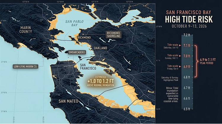
The NWS specifically expects impacts to low-lying lots, parks and roads, with isolated road closures possible. Coastal trails and beaches could also become difficult or temporarily impossible to access.
That distinction matters for tourism. A visitor may be able to travel normally through much of San Francisco while encountering flooding only a few blocks from the shoreline.
The Embarcadero Is One Of The Places To Watch
San Francisco’s waterfront makes the city particularly sensitive to unusually high tides.
The Embarcadero is one of the Bay Area’s most recognizable public waterfront corridors, connecting attractions, piers, ferry facilities, restaurants and open spaces along the eastern side of the city.
Previous high-water events have shown how quickly elevated tides can move from being an interesting natural phenomenon to a transportation concern. Water can reach portions of waterfront walkways and low-lying infrastructure even without a major storm.
The current NWS advisory specifically warns that high tides can bring water and waves farther up the beach than normal and restrict access to low-lying coastal areas.
For visitors planning waterfront sightseeing, photography or cycling, the important factor is timing. Conditions around high tide can be very different from those just a few hours earlier.
Travelers should also avoid assuming that a flooded road is shallow enough to cross. The NWS advises allowing extra time when travel is necessary, avoiding barricades and never driving through water of unknown depth.
San Pablo Bay And Marin County Face Their Own Exposure
The risk extends beyond central San Francisco.
The current advisory also covers bayshore locations around San Pablo Bay, including parts of the North Bay. The National Weather Service says up to 1.2 feet of inundation is possible in low-lying areas, with potential flooding of infrastructure, isolated road closures and coastal erosion.
Communities around Marin County and the northern Bay therefore need to watch local tide levels rather than relying on conditions observed in San Francisco.
The geography of the Bay makes localized impacts especially important. Water can move through tidal channels and wetlands while producing different effects from one shoreline to another.
For travelers exploring Sausalito, Tiburon, Larkspur, San Rafael and other waterfront communities, the safest approach is to check local conditions before committing to shoreline routes.
This is particularly relevant for cyclists and pedestrians. A route that normally provides an easy connection between waterfront parks can become temporarily inaccessible when high water reaches a trail or low section of roadway.
Visitors planning a broader trip can use the California destinations guide to build alternatives that do not depend entirely on exposed waterfront locations.
A Kelvin Wave Is Raising The Ocean From Below
One of the most unusual elements of the current situation is a phenomenon many travelers may never have heard of: the coastal Kelvin wave.
NOAA Fisheries published an explanation on October 6 describing a Kelvin wave currently moving north along the North American West Coast. Unlike ordinary waves at the beach, Kelvin waves are enormous underwater disturbances that can alter sea level and ocean temperature over broad distances.
NOAA oceanographer Michael Jacox explained that these waves commonly form in the western equatorial Pacific, move eastward and then continue along coastlines after reaching the Americas.
The current wave is traveling north along the West Coast at roughly 6 miles per hour, or about 150 miles per day.
Its effect on sea level is significant because a Kelvin wave can temporarily add approximately 6 to 12 inches to coastal water levels.
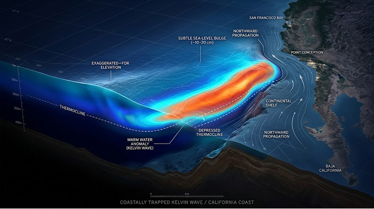
By itself, NOAA says that increase does not normally pose a major threat. The problem occurs when the elevated baseline coincides with very high astronomical tides or storm surge. The higher starting water level leaves less room before flooding begins.
That is exactly the type of interaction California is now watching.
El Niño Is Adding More Heat To The Pacific
The Kelvin wave is closely connected to the developing El Niño.
During El Niño, changes in tropical Pacific winds and ocean circulation help move warm water eastward. Some of that heat eventually influences the eastern Pacific and the waters along California.
NOAA says the current Kelvin wave is one of the mechanisms through which El Niño affects the U.S. West Coast. As the wave passes, it can raise sea levels and increase ocean temperatures while weakening the normal coastal upwelling that brings cold, nutrient-rich water toward the surface.
California’s current ocean conditions are therefore relevant for more than flooding.
Warmer coastal water can affect marine ecosystems, fisheries and the timing and distribution of marine species. NOAA notes that reduced upwelling can also affect phytoplankton, which form an important base of the marine food web.
For a state where whale watching, fishing, boating and coastal recreation contribute significantly to the visitor economy, these changes could become increasingly noticeable as the El Niño develops.
California Is Preparing For A Strong El Niño Winter
The coastal flooding comes as California agencies prepare for a potentially intense winter weather pattern.
On October 1, the California Department of Water Resources announced that the state was preparing for potential extreme weather emergencies as Water Year 2027 began. DWR Director Tom Gibson said California was taking action ahead of the potential flood season because strong El Niño conditions could produce major swings between dry and wet conditions.
The implications extend well beyond the Bay Area.
A strong winter storm arriving during an elevated tide can create substantially greater coastal impacts than either event would produce separately. High water can limit the effectiveness of drainage systems, increase erosion and push waves farther inland.
The Bay Area’s transportation network is particularly exposed because major roads, transit infrastructure, neighborhoods and commercial areas are concentrated around the shoreline.
This makes the timing of future storms important.
A moderate storm occurring during a relatively low tide may produce limited coastal flooding. The same storm arriving during one of the year’s highest tides could create much more serious problems.
Winter King Tides Could Become The Bigger Test
The October flooding is an early indication of what could happen later in the year.
San Francisco is expected to experience an unusually large number of exceptionally high tides during the coming winter as El Niño and elevated ocean levels continue to influence the coast. Recent reporting has estimated around 30 potentially flood-inducing high tides between November and February, although the exact count depends on how “king tide” is defined.
The highest-risk periods are expected around major holiday travel dates and other winter peaks.
That could matter for Thanksgiving and Christmas visitors who plan to spend time around San Francisco’s waterfront.
Holiday travel already puts additional pressure on roads, parking facilities and public transportation. Add unusually high tides, heavy rain and strong winds, and relatively small coastal impacts can quickly become larger travel problems.
The issue is not that San Francisco should expect continuous flooding throughout the winter. Instead, travelers may encounter short windows when certain waterfront areas become inaccessible or transportation becomes more difficult.
Coastal Travel May Look Different This Fall And Winter
For California visitors, the developing pattern changes how coastal trips should be planned.
A typical itinerary might combine the Embarcadero, Golden Gate Bridge, Sausalito, coastal parks and beaches. Under normal weather conditions, those destinations can be visited with little concern about tide timing.
This season, tide charts deserve more attention.
Visitors should check the forecast before traveling to low-lying waterfront locations, especially when heavy rain or strong winds are also predicted. Cyclists should have alternate routes available. Drivers should avoid flooded roadways and never bypass barricades.
People visiting beaches should also be aware that higher water can reduce the amount of accessible shoreline even when waves appear relatively modest.
The National Weather Service warns that rising tides can restrict escape routes from beaches and coastal areas.
That makes tide awareness particularly important for anyone exploring isolated shoreline paths, tidal wetlands or beaches during high tide.
The Bay Area Is Entering A New Coastal Baseline
The significance of the current flooding is not simply that San Francisco is experiencing another high tide.
The larger story is the changing baseline.
NOAA’s analysis shows that Kelvin waves can temporarily raise sea level by 6 to 12 inches. El Niño can add warmer water and weaker upwelling. Long-term sea-level rise continues to raise the average ocean level. Astronomical tides then create predictable peaks on top of those changes.
Each factor is manageable on its own.
Together, they reduce the amount of additional water needed to push low-lying areas into minor flooding.
That is why coastal flooding can occur without a hurricane, major storm or dramatic wave event.
For California Times readers, this distinction is important. The current San Francisco Bay flooding is not a prediction that the city will be submerged. It is a real-time example of how relatively small changes in sea level can alter the practical use of waterfront spaces.
What Bay Area Visitors Should Watch This Week
The current advisory runs through Tuesday afternoon, with the highest forecast tides concentrated from Saturday through Monday.
Visitors planning Bay Area activities during that window should:
- Check the latest National Weather Service coastal flood advisory before leaving.
- Avoid driving through standing water or around road barricades.
- Give themselves additional travel time if using low-lying waterfront roads.
- Check tide times before visiting beaches, coastal trails and tidal parks.
- Keep inland alternatives available if waterfront access becomes restricted.
The situation is dynamic, so forecasts can change as ocean conditions evolve.
The latest NOAA analysis also suggests that the Kelvin wave will continue moving along the West Coast, meaning the current episode should be viewed as part of a broader seasonal pattern rather than a single isolated tide event.
San Francisco Bay is therefore becoming an early test of how California’s coastline will respond when an unusually strong El Niño meets high tides, warmer water and a rising long-term sea-level baseline.
For travelers, the message is straightforward: the Bay Area remains open for exploration, but waterfront plans this fall and winter will require more attention to tides, coastal flooding and weather than they have in a typical October.