
San Clemente’s coastline is losing the sand that once separated its beaches from one of Southern California’s most important transportation corridors. At North Beach, erosion has narrowed the shoreline, damaged sections of the pedestrian beach trail and pushed waves closer to railroad tracks carrying Amtrak Pacific Surfliner, Metrolink, freight and military traffic.
The problem is no longer simply about losing recreational beach space. The Orange County Transportation Authority says erosion has exposed portions of the railroad embankment, damaged existing rock protection and increased direct wave attack on the coastal rail line. On September 28, the OCTA Board moved to address an emergency need for additional shoreline protection and sand placement before another round of high waves and winter storms arrives.
San Clemente now faces a difficult coastal-management problem: officials estimate the city has a sand deficit of roughly 3 million cubic yards, while the transportation agency is planning up to 540,000 cubic yards of new sand along vulnerable portions of the rail corridor. The proposed nourishment is intended to restore a buffer between the Pacific Ocean and the railroad, but officials acknowledge that sand alone cannot provide a permanent solution.
San Clemente Has Lost More Than A Walkable Beach
For decades, residents and visitors could walk along a broad stretch of sand from North Beach toward the San Clemente Pier and southern parts of the city. That continuous beach has been broken up by erosion, slope failures and emergency infrastructure work.
Recent reporting by the Associated Press described North Beach as dramatically transformed, with the shoreline pushed inland and portions of the beach effectively disappearing. Resident Cameron Cosgrove, who helped write a proposed local tax measure for beach restoration, told the AP that the city has lost the walkable beach experience that once connected different parts of the waterfront.
The physical changes are also affecting access. The city says the Beach Trail between North Beach and Linda Lane has been subject to closures as OCTA works on an approximately 1,400-foot catchment wall designed to protect the railroad and restore the pedestrian trail. The project is part of a larger emergency program addressing four areas where erosion and unstable slopes threaten the coastal rail line. San Clemente’s current project updates provide the latest information on construction and trail restrictions.
The loss of sand matters because the beach itself functions as a natural buffer. Waves normally expend some of their energy across the width of the beach before reaching the bluffs, seawalls, riprap or railroad embankment. When that beach becomes narrower, waves can reach protective infrastructure with greater force and frequency.
That creates a cycle in which erosion threatens the infrastructure designed to protect the transportation corridor, while emergency repairs can temporarily alter the shoreline and public access.
The Railroad Runs Directly Along A Vulnerable Coastline
The San Clemente rail corridor is part of the LOSSAN rail corridor, which runs between Los Angeles, San Diego and San Luis Obispo. The section through San Clemente is especially sensitive because the railroad occupies a narrow strip between coastal bluffs and the Pacific Ocean.
OCTA’s Coastal Rail Resiliency Study covers approximately 7 miles of railroad through Dana Point and San Clemente to the Orange County-San Diego County line. The agency is evaluating strategies intended to protect the existing alignment and maintain safe passenger and freight operations for up to 30 years. More than $300 million in state, federal and local funding has been secured for priority rail-protection efforts.
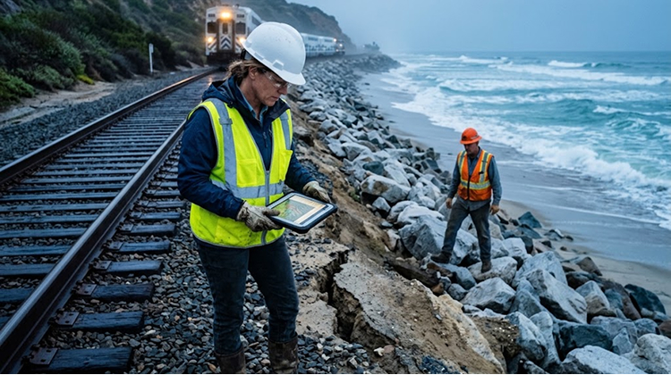
The corridor carries multiple types of traffic. Amtrak Pacific Surfliner trains use the line, as do Metrolink commuter trains and freight operations. The route also serves military transportation, making interruptions relevant beyond ordinary passenger travel. OCTA describes the LOSSAN corridor as one of the nation’s busiest passenger and freight rail corridors.
The vulnerability became particularly clear on September 8, 2026, when severe waves and high tides forced a temporary closure of the coastal rail line. OCTA said waves overtopped the tracks and caused additional deterioration along the adjacent slope, including damage to portions of previously installed protective rock. The closure affected Metrolink, Amtrak Pacific Surfliner and freight operations while crews inspected and stabilized the area. OCTA’s rail closure update documents the incident.
The September closure was a warning of what can happen when the ocean reaches the railroad with too little beach between them.
The Rail Line Has Already Required Emergency Protection
Sand is only one component of the response.
OCTA and Metrolink have already used large boulders, known as riprap, to protect sections of the railroad. In Areas 1 and 2 near North Beach and Mariposa Point, approximately 5,900 tons of riprap were installed within the existing protective footprint during earlier stabilization work.
The emergency program now covers four reinforcement areas.
Areas 1 and 2 face deterioration of existing rock protection. Area 3 has unstable bluff conditions and requires a catchment wall. Area 4, farther south near mileposts 206.00 to 206.70, has locations where erosion has exposed the railroad embankment and where little or no riprap protection remains.
The latest OCTA board action on September 28 called for immediate measures in Area 4, including an engineered shoreline-protection structure, repairs to existing riprap and sand placement in several reinforcement areas. The agency cited continued beach loss, embankment erosion and increased wave exposure as reasons for the emergency response.
OCTA’s project design calls for approximately 95% sand and 5% rock reinforcement across the broader emergency program. That balance reflects the agency’s effort to rebuild a beach buffer while using harder infrastructure only where necessary to protect the railroad.
High Waves Have Already Reached The Tracks
The September 8 rail closure demonstrated how quickly conditions can change.
OCTA said high tides and powerful wave activity caused waves to overtop the railroad tracks. The adjacent slope deteriorated, while some existing protective rock was damaged. Crews had to close the corridor to safely evaluate the damage and perform emergency stabilization.
The event came after a summer of unusually active Pacific conditions along Southern California. The region has experienced powerful swells associated with Pacific storms and hurricanes, removing sand from beaches that were already suffering from chronic sediment shortages.
Reuters reported in September that Southern California’s coast has experienced severe erosion during the 2026 summer, with rising sea levels, strong storms and El Niño adding pressure to already vulnerable beaches. The report also noted that temporary El Niño-related sea-level effects can increase coastal exposure during high tides and storms.
San Clemente’s geography leaves little margin for that additional water and wave energy. The railroad cannot simply move farther inland without a major infrastructure project, and the beach cannot be widened indefinitely without finding a sustainable source of sediment.
That is why the current work is being treated as an emergency rather than routine beach maintenance.
El Niño Could Make The Winter More Difficult
The timing of the rail emergency is especially significant because California is entering a strong El Niño pattern.
NOAA has reported unusually warm waters in the eastern equatorial Pacific and a high probability of a very strong El Niño during the Northern Hemisphere fall and winter. El Niño does not guarantee a specific storm pattern at San Clemente, but it can alter Pacific storm tracks, wave conditions and coastal water levels.
For San Clemente, the concern is cumulative exposure.
A beach that has already lost substantial sand begins the winter with less natural protection. A sequence of large waves can remove additional sediment. High tides can allow waves to reach farther landward. Heavy rainfall can destabilize coastal slopes. Each process can reinforce the others.
That is especially important along a railroad where even localized damage can disrupt service across a much larger region.
OCTA’s September 28 emergency resolution specifically cited forecasted El Niño conditions as a reason to accelerate protective work before additional high-wave and winter-storm events.
The agency is therefore trying to build protection before the most challenging part of the season arrives, rather than waiting for another track closure to force the issue.
San Clemente Needs Millions Of Cubic Yards Of Sand
The scale of the sand deficit is one of the clearest indicators of how much the coastline has changed.
San Clemente City Manager Andy Hall recently estimated that the community is short roughly 3 million cubic yards of sand. The Associated Press reported that replacing that amount by truck would require approximately 300,000 truck trips, illustrating why simply hauling sand from inland sources is not an easy answer.
OCTA’s current emergency program is considerably smaller, but still represents one of the largest beach-nourishment efforts ever planned for San Clemente.
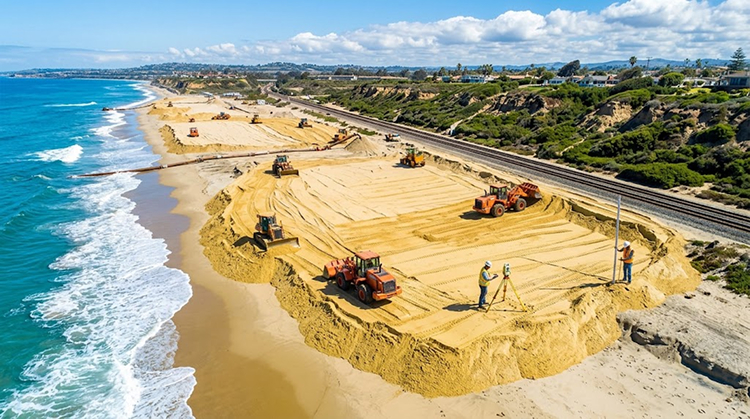
The agency expects to place up to 540,000 cubic yards of sand along vulnerable sections of the coastline. About 240,000 cubic yards are planned between Mariposa Point and North Beach, while another 300,000 cubic yards would be placed south of San Clemente State Beach. OCTA estimates the material could create an approximately 50- to 80-foot-wide dry beach, although the actual width will vary depending on tides, existing conditions, seasonal changes and how well the sand remains in place.
| San Clemente Coastal Rail Protection | Current Figure |
|---|---|
| Estimated citywide sand deficit | ~3 million cubic yards |
| Planned OCTA sand nourishment | Up to 540,000 cubic yards |
| Mariposa Point–North Beach allocation | ~240,000 cubic yards |
| South of San Clemente State Beach | ~300,000 cubic yards |
| Approximate potential dry-beach width | 50–80 feet |
| Coastal rail corridor under study | ~7 miles |
The difference between the estimated deficit and the planned nourishment is significant. The 540,000-cubic-yard project represents an important intervention, but it would replace only a portion of the sand officials say the coastline has lost.
Casa Romantica Shows How Wide The Erosion Problem Has Become
The railroad is not the only major piece of San Clemente infrastructure dealing with unstable coastal slopes.
The Casa Romantica Cultural Center and Gardens, located above the ocean near Avenida Granada, suffered a major landslide on April 27, 2023. Approximately half an acre of gardens, including the Ocean Terrace and Native Bowl gardens, was lost during the slide.
The city completed Phase I of the cliff stabilization project in 2026. Phase II, which addresses damaged amenities and structural components, remains subject to Coastal Commission review and other approvals. Casa Romantica announced on September 1 that the Ocean Terrace and portions of the surrounding gardens had partially reopened. Casa Romantica’s latest construction update provides the current visitor information.
The Casa Romantica landslide and the railroad erosion are different engineering problems, but they illustrate the same geographic reality: much of San Clemente’s valuable public infrastructure sits within a narrow and dynamic coastal zone.
For visitors, that can mean changing trails, temporary closures and altered beach access even when the city itself remains open.
Officials Are Studying What Happens If The Railroad Cannot Stay Where It Is
Emergency repairs are designed to protect the railroad in its current location. The longer-term question is more complicated.
OCTA’s Coastal Rail Resiliency Study is evaluating ways to protect approximately seven miles of the existing corridor for up to 30 years. At the same time, a separate state-led effort is examining longer-term solutions beyond that period.
Possible strategies include additional beach nourishment, engineered shoreline protection, slope stabilization and other infrastructure measures. Longer-term discussions have also included the possibility of relocating the rail line inland or considering whether portions of the existing coastal alignment can remain viable.
Those options carry major financial, engineering, environmental and community consequences. The LOSSAN corridor is an important transportation link, while the coastline is also a recreational resource and environmentally sensitive area.
There is no single solution that eliminates all of those competing considerations.
San Clemente’s Beach Future Will Depend On More Than One Sand Project
The planned 540,000 cubic yards of sand could restore a substantial portion of the beach buffer in targeted areas, but coastal sand does not stay perfectly in place.
OCTA notes that sand moves laterally through longshore drift and experiences seasonal changes. That is one reason the agency considers nourishment only one component of its broader protection strategy. Riprap, revetments, catchment walls and other engineered measures remain necessary where erosion has created an immediate threat to the railroad.
The same pattern is visible elsewhere along Southern California’s coast. Newport Beach is pursuing a separate 200,000-cubic-yard sand transfer from the Santa Ana River area as officials respond to severe erosion at The Wedge and surrounding beaches. CaliforniaTimes recently documented how Newport Beach coastal erosion is exposing buried infrastructure as sand disappears.
San Clemente’s situation is more consequential for regional transportation because the railroad sits immediately behind the shrinking beach.
The coming winter will test whether the combination of sand nourishment, rock protection and slope stabilization can provide enough separation between the Pacific and the tracks.
For San Clemente residents, surfers, beach walkers and rail passengers, the stakes are visible in the changing shoreline. The issue is no longer simply whether the city will have a wide beach next summer. It is whether a major transportation corridor can continue operating safely along a coastline that is steadily losing the natural buffer that once protected it.