
The Wedge in Newport Beach has always been one of Southern California’s most recognizable surf spots, but the danger along the shoreline is changing. Powerful swells have stripped away so much sand that rocks, wooden pilings, concrete fragments, pipes, wires and rusted metal once buried beneath the beach are now visible or sitting in the surf zone.
The transformation is happening as California enters an unusually strong El Niño pattern. The National Oceanic and Atmospheric Administration reported in September that sea-surface temperature anomalies in the eastern equatorial Pacific had exceeded 3°C, with more than a 90% chance of a very strong El Niño during fall and winter 2026–27. NOAA’s El Niño outlook provides the larger climate context for the coastal conditions now developing in Southern California.
At The Wedge, the result is visible at ground level. The famous triangular break remains a major attraction for surfers, bodyboarders and spectators, but the beach itself has become narrower and more uneven. The combination of powerful waves, high tides and reduced sand cover is creating hazards that visitors cannot identify simply by looking at the water.
The Wedge Has Lost A Significant Amount Of Beach Sand
The recent erosion is not a small change in the appearance of the beach. Reporting from the Los Angeles Times and Wall Street Journal has documented extensive sand loss at The Wedge and the emergence of material that had remained buried for decades.
During powerful summer swells, waves reaching around 20 feet at the break repeatedly attacked the shoreline. The sand was pulled away from areas near the jetty, revealing loose boulders, chunks of concrete and rusted metal. The Wall Street Journal reported in September that the exposed material includes wooden pilings, rebar and pipes, while the Los Angeles Times documented similar infrastructure remnants after hurricane-driven swells earlier in the summer.
The change is particularly important because sand normally provides a protective buffer between incoming waves and the back beach. When that buffer becomes thinner, waves can break closer to the shoreline and reach areas that normally remain separated from direct wave energy.
That relationship is well established in coastal science. A USGS study of California beach erosion found that the 2015–16 El Niño produced unusually high wave energy and substantial erosion across California, with southern California experiencing an average of 9.7 meters of erosion across the studied transects. The response varied significantly by location, but researchers found a strong relationship between cumulative wave energy and shoreline change.
The current conditions at Newport Beach are therefore part of a much larger coastal process, although the exact amount of sand lost at The Wedge varies as new swells move sediment around.
Decades-Old Infrastructure Is Now Appearing At The Shoreline
The most unusual feature of the current erosion is what the missing sand has revealed.
The Wedge is not an untouched stretch of beach. Its distinctive surf characteristics are closely connected to the Newport Harbor jetty system, which was extended in the 1930s. The structure changes how incoming waves interact with the shoreline and helps create the unusually large, powerful waves for which the location is famous.
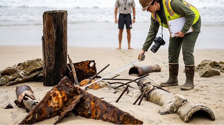
As sand levels have dropped, pieces of the area’s older infrastructure have emerged. Recent reports have described exposed pipes, wires, wooden pilings, rocks and metal rods. Some objects are close to the shoreline while others can become difficult to see once waves and tides cover them again.
That creates a different type of beach hazard from the normal risks associated with The Wedge.
A large wave can injure a surfer through impact with the water, another person or the ocean floor. An exposed piece of metal or timber introduces a fixed obstacle into an environment where people can be thrown several yards by a breaking wave.
For visitors, the important distinction is that the beach can change from one day to the next. An object visible at low tide may disappear beneath water during a higher tide. A section of sand that looks stable from a distance may also contain rocks or debris immediately beneath the surface.
The Surf Remains Powerful Even As The Beach Changes
The erosion has occurred alongside some of the biggest surf seen at The Wedge in recent memory.
The break is famous for producing unusually steep waves because of the angle of the jetty and the way incoming swell interacts with the structure. During the strongest recent swells, wave faces around 20 feet were reported at the location.
That combination explains why The Wedge continues attracting crowds even as the beach becomes more hazardous. The same ocean conditions removing sand are also producing the dramatic surf that draws experienced surfers, photographers and spectators.
Newport Beach lifeguards have been particularly busy during recent high-surf periods. During one Saturday over the Labor Day weekend, Newport Beach Lifeguard Battalion Chief Mike Ure said the department recorded 179 rescues and about 5,000 preventive interventions. Newport Beach lifeguard safety guidance also emphasizes staying near lifeguard towers, paying attention to warning flags and remaining aware of changing conditions.
The numbers show why beach safety cannot be judged by wave size alone. Rip currents, shorebreak, submerged objects, steep sand edges and changing tides can all affect conditions simultaneously.
El Niño Is Adding Another Layer To Newport Beach’s Erosion Problem
El Niño does not simply mean that every California beach will experience the same amount of erosion. Local shoreline shape, wave direction, tides, structures and existing sand levels all influence how a particular beach responds.
But historical research shows why coastal officials are paying close attention.
The U.S. Geological Survey’s research on El Niño and California beaches found that the 2015–16 event produced winter beach erosion that was 76% above normal across 29 beaches studied along the U.S. West Coast. Most of the California beaches in that study eroded beyond historical extremes.
The present El Niño is already unusually strong. NOAA’s September assessment found the Niño-3.4 index at +1.8°C, while Niño-3 reached +2.5°C and Niño-1+2 reached +3.4°C. NOAA said the probability of a very strong event during the Northern Hemisphere fall and winter exceeded 90%.
That does not mean Newport Beach will experience a repeat of any particular historical El Niño. It does mean the coast is entering the winter with less room for error after months of strong swells have already removed substantial quantities of sand.
For visitors, the practical concern is straightforward: the beach seen in September may not look the same after another sequence of large swells, high tides and storms.
Newport Beach Is Bringing In 200,000 Cubic Yards Of Sand
The erosion has already triggered a major response beyond The Wedge itself.
On September 18, Orange County Supervisor Katrina Foley announced an agreement involving OC Public Works and the City of Newport Beach to move 200,000 cubic yards of sand from the Santa Ana River outlet to Newport Beach’s eroding shoreline.
The project was accelerated after Orange County communities experienced severe coastal erosion and high surf. Orange County’s sand-transfer announcement said the material would be used to address erosion along the Newport Beach shoreline as officials prepare for the coming El Niño season.
The decision illustrates the scale of the problem. Moving 200,000 cubic yards is a major sediment-management operation, not a routine beach cleanup.
It also reflects a larger California coastal dilemma: adding sand can restore some of the protective beach profile, but coastal sediment moves constantly. Waves and currents can redistribute placed sand, sometimes transporting it away from the location where it was deposited.
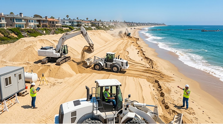
That is why beach nourishment is usually treated as part of a continuing coastal-management strategy rather than a permanent fix.
The City Is Studying What The Erosion Means For The Wedge
Newport Beach officials are also examining the underlying problem.
The Newport Beach City Council voted unanimously in August to study the erosion at The Wedge and consider possible responses. The motion was proposed by Councilmember Erik Weigand, who has a personal connection to the surf community. Recent reporting identified the study as a response to the unusual loss of sand and the newly exposed infrastructure.
The City of Newport Beach Council records provide access to meeting agendas, packets and minutes as the city evaluates coastal and infrastructure issues.
The study matters because The Wedge is a highly engineered coastal environment. Any intervention could affect more than the immediate beach.
The jetty influences wave behavior. Sand movement affects adjacent beaches. Changes to the shoreline can alter access, public safety and the exposure of existing infrastructure. A solution that protects one section of beach may change sediment movement somewhere else.
That makes the problem more complicated than simply replacing whatever sand has disappeared.
High Tides Are Making The Current Conditions More Difficult
Sand loss is only one part of the current risk.
The National Weather Service issued a Beach Hazards Statement covering Orange County and San Diego County beaches through September 30. The latest advisory calls for surf of roughly 3 to 5 feet with sets up to 6 feet, astronomical tides reaching 6.5 to 7 feet, minor tidal overflow and moderate coastal erosion during high tides. Strong rip currents are also expected. The latest NWS Orange County beach forecast specifically identifies Orange County coastal areas as being affected.
Those numbers matter at a beach that has already lost substantial sand.
High tides allow waves to reach farther inland across a narrowed beach. When elevated surf arrives at the same time, the water can attack the shoreline from a higher starting point.
The result can include steep sand faces, temporary drop-offs and newly exposed objects.
For beachgoers, that means the safest route is not necessarily the route that was available earlier in the summer.
Visitors Should Treat The Wedge As A Changing Coastal Environment
The Wedge remains a public beach and an iconic Newport Beach destination, but the current landscape calls for a different level of awareness.
Visitors should avoid climbing unstable sand cliffs, stay clear of exposed pipes and metal, watch for changing water levels and follow instructions from Newport Beach lifeguards. Surfers and bodyboarders should also recognize that submerged hazards may not be visible from shore.
The National Weather Service advises people to remain out of the water during hazardous swimming conditions, particularly when rip-current risk is elevated.
People who visit primarily to watch the waves should also keep a safe distance from the edge of the water. The largest waves can surge farther up the beach than expected, especially when combined with a rising tide.
The current scene is striking partly because it exposes a hidden chapter of Newport Beach’s coastal history. But the objects emerging from the sand are reminders that the shoreline is constantly moving.
That lesson connects The Wedge to other Southern California beaches already experiencing serious erosion. Recent damage at Aliso Beach and elsewhere has shown how quickly a major swell can reshape access, parking areas and coastal infrastructure. CaliforniaTimes has previously documented these Southern California coastal erosion impacts in Laguna Beach.
The Bigger Question Is What Happens Before Winter
The Wedge’s current appearance is a snapshot of a shoreline under unusual pressure.
Hurricane-driven swells already removed significant quantities of sand. El Niño is strengthening. High astronomical tides are periodically pushing water farther onto the beach. Newport Beach and Orange County are responding with emergency sand movement, while city officials study the longer-term erosion problem.
The immediate objective is to restore some beach width and reduce exposure to hazards. The longer-term question is how the shoreline will behave if another series of powerful swells arrives before the beach naturally recovers.
Historical USGS research shows that California beaches can respond dramatically during strong El Niño winters, but it also shows that the response varies from one location to another.
At The Wedge, the most visible warning is already sitting in plain sight: material that spent decades hidden beneath the sand has become part of the shoreline again.
For Newport Beach, the coming months will determine whether those exposed remnants remain an unusual summer discovery or become an early sign of a much larger coastal erosion challenge.