
Two wildlife crossings planned for State Route 62 near Joshua Tree National Park are entering a new phase of environmental studies and design as conservation groups work to reconnect one of the Mojave Desert’s most important wildlife corridors.
The proposed overpasses would cross SR-62 at the Morongo Grade and Yucca Grade, creating safe routes for mountain lions, desert bighorn sheep, mule deer, black bears, bobcats, desert tortoises and other animals that currently face a major highway barrier between protected mountain habitats.
The project has received $5.5 million from California’s Wildlife Conservation Board, another $512,000 from the Coachella Valley Mountains Conservancy and $100,000 previously provided by Caltrans District 8 for planning and design. The money supports the work needed to bring the crossings to roughly 65% design, but it does not pay for construction itself.
Recent reporting in late September 2026 has brought renewed attention to the project because researchers are now gathering field data that will influence where and how the crossings are built. The effort comes after an 18-month-old male mountain lion was killed by a vehicle on the Yucca Grade in April.
The project is about much more than one species. It is an attempt to reconnect habitat that once functioned as a continuous landscape between the San Bernardino Mountains and Little San Bernardino Mountains, including the area around Joshua Tree and the Sand to Snow National Monument.
Two Wildlife Crossings Are Planned For State Route 62
The proposed structures would be located at two particularly difficult points along SR-62: the Morongo Grade and Yucca Grade.
State Route 62 cuts through the desert corridor connecting protected lands on both sides of the highway. According to the Mojave Desert Land Trust, studies have found that the highway has become an almost complete barrier to wildlife movement at these locations.
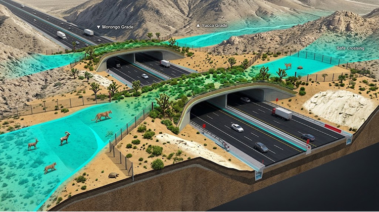
The proposed crossings are being developed as broad, earthen overpasses rather than conventional concrete bridges. Native vegetation would be incorporated into the structures so that the landscape continues across the highway instead of creating an artificial-looking platform above traffic.
The project also calls for wildlife fencing along the highway near each crossing. Fencing is important because an overpass by itself would not necessarily keep animals away from traffic. The system is intended to guide animals toward the safer crossing points.
The State Route 62 wildlife crossings project is being led by the Mojave Desert Land Trust in partnership with Caltrans, the Coachella Valley Conservation Commission and the Mojave Desert Resource Conservation District. Wildlife agencies, scientists, tribal groups and other stakeholders are participating in the planning process.
The Highway Separates Major Desert Habitats
The ecological significance of SR-62 becomes clearer when the road is viewed as part of the larger Southern California landscape.
Joshua Tree National Park occupies nearly 795,000 acres, while the surrounding mountains and protected lands create a much larger network of desert and mountain habitat. The park recorded 2,932,644 recreation visits in 2025, making the surrounding transportation network increasingly important for both visitors and wildlife.
The Mojave Desert Land Trust describes the historic connection between the San Bernardino and Little San Bernardino mountain ranges as a roughly 95-mile habitat corridor before modern development and transportation infrastructure disrupted portions of that connection.
The organization says the SR-62 crossings would reconnect habitat involving Joshua Tree National Park, the Sand to Snow National Monument, San Gorgonio Wilderness and San Bernardino National Forest.
This geographic connection matters because animals need to move in response to food availability, reproduction, water and changing environmental conditions. A highway can become a narrow but powerful barrier even when the surrounding landscape remains undeveloped.
The National Park Service Joshua Tree overview shows how large and ecologically diverse the park remains, with 57 mammal species documented alongside hundreds of bird and plant species.
For visitors, the highway is primarily a route into and around the desert. For wildlife, it can represent a dangerous break in an otherwise continuous landscape.
Researchers Are Studying Wildlife Before Construction
The crossings are still years away from opening.
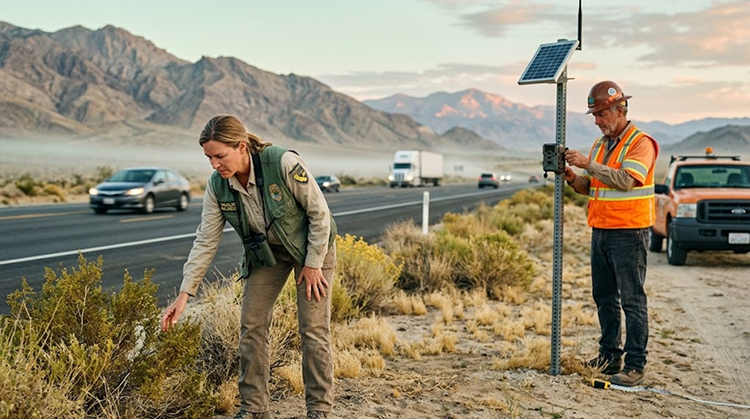
Current work is focused on collecting the scientific information needed to determine how animals use the corridor. Researchers are conducting wildlife surveys around the proposed crossing locations, with additional monitoring planned as the project moves through design and environmental review.
One of the more unusual elements of the research involves collecting animal scat for DNA analysis.
DNA samples can help researchers identify which species are using the corridor and provide information about movement patterns and genetic connections between populations. Detection dogs are also expected to assist with locating scat and other evidence of wildlife activity.
The fieldwork is important because planners need more than a map showing where animals have been killed. They need information about how animals move through the landscape, which routes they prefer and whether different species use the corridor at different times.
The project website says wildlife surveys and monitoring will help establish a baseline that can later be compared with wildlife activity after the crossings are constructed.
Mountain Lions Are Only Part Of The Wildlife Equation
The name “mountain lion crossings” captures the most recognizable part of the project, but the structures are intended to serve a much larger group of animals.
Potential users include:
- Desert bighorn sheep
- Mountain lions
- Mule deer
- Black bears
- Bobcats
- Desert tortoises
- Coyotes
- Badgers
- Gray foxes
- Smaller mammals, reptiles and pollinators
Each species interacts with the desert differently.
A mountain lion may travel considerable distances through rugged terrain while searching for territory or prey. A desert tortoise moves much more slowly and faces different risks from traffic. Bighorn sheep depend on access to connected mountain environments, while smaller species may use vegetation along the crossing itself.
The proposed design accounts for that range of behavior. The crossings are expected to use gentle slopes, native vegetation and fencing that guides animals toward the overpasses.
The Caltrans wildlife connectivity program identifies wildlife-vehicle collision locations throughout California and tracks barriers where highways interfere with animal movement. Caltrans’ July 2026 statewide report represents the first required baseline inventory under California’s wildlife-connectivity program.
A Mountain Lion Was Killed At One Of The Proposed Crossing Sites
The need for the project became especially visible on April 26, 2026, when a healthy male mountain lion approximately 18 months old was struck and killed by a vehicle on the Yucca Grade.
The California Department of Fish and Wildlife determined that the animal was moving from the San Bernardino Mountains side of the highway toward Joshua Tree National Park when it was hit.
The location was close to one of the proposed wildlife crossings.
For researchers, the incident illustrated the problem created when a highway cuts directly through a wildlife corridor. Animals still attempt to move across the landscape because their habitat, food sources and reproductive ranges do not follow human transportation boundaries.
The April death also occurred only months after California regulators determined that mountain lion populations in Southern California and the central coast warranted protection as a threatened species under the California Endangered Species Act. The California Fish and Game Commission cited habitat loss, fragmentation and isolation among the threats considered during the February 2026 decision.
That designation adds another layer to the SR-62 project because maintaining connections between mountain habitats can be important for the long-term movement and genetic exchange of isolated populations.
Joshua Tree Is Seeing Millions Of Visitors Each Year
The wildlife project is unfolding alongside a major tourism economy.
Joshua Tree National Park recorded almost 2.93 million visitors in 2025, following nearly 3 million visits in 2024 and more than 3.27 million in 2023. The park’s busiest visitor season generally runs from October through May.
The increase in human activity around the region creates a complicated transportation picture. Visitors need reliable roads to reach communities and recreation areas, while wildlife needs safe routes across the same transportation network.
The National Park Service warns visitors that congestion can become significant during busy periods, with entrance lines, crowded parking areas and full campgrounds.
The Joshua Tree visitor guidance also emphasizes preparation because services such as food, water and fuel are limited or unavailable inside much of the park.
The SR-62 crossings are not expected to change visitor access to Joshua Tree in the immediate future. They are an infrastructure and conservation project developing outside the park’s normal visitor experience.
The longer-term goal is to make the road compatible with the wildlife corridor rather than forcing one system to compete with the other.
The Crossings Will Look More Like Desert Landscape Than Bridges
The visual concept is different from a conventional highway overpass.
Instead of a narrow concrete bridge, planners envision broad earthen structures covered with native vegetation. The slopes would rise gradually from the surrounding desert, giving animals a route that resembles natural terrain.
This approach is important because wildlife does not automatically treat a structure as safe simply because it passes above traffic.
Noise, lighting, fencing, vegetation and the shape of the crossing can all affect whether animals use it. The project therefore includes measures addressing highway light and noise along with directional fencing.
The proposed structures also need to fit the surrounding terrain. Geological conditions, utilities, highway engineering and neighboring properties are among the factors still being evaluated before the final designs are established.
The Mojave Desert Land Trust says the exact locations and designs will continue to be refined as environmental and technical studies progress.
The Planning Phase Is Fully Funded, But Construction Is Not
The current funding provides a significant step forward, but it does not mean construction crews are about to begin building the crossings.
California’s Wildlife Conservation Board awarded $5.5 million for environmental review and design in February. The Coachella Valley Mountains Conservancy then approved a $512,000 planning grant in May, while Caltrans had previously contributed $100,000.
Together, those funds support the planning phase and are expected to move the project toward approximately 65% design completion.
Construction will require another round of funding.
The project timeline also reflects the amount of work still ahead. The Mojave Desert Land Trust says the current effort is a three-year project involving engineering surveys, environmental permitting, technical studies and design.
The organization expects the designs to reach 65% completion by the end of 2028, after which partners will pursue the funding needed for construction.
That means the crossings are a long-term infrastructure project rather than an immediate road improvement.
The Wildlife Data Could Matter For Decades
One of the most significant aspects of the project may occur before a single piece of construction equipment reaches the highway.
Researchers are establishing a record of animal movement that can be used to evaluate whether the crossings eventually change how wildlife moves through the region.
DNA information can be especially useful because it provides evidence that goes beyond simple sightings. A camera can show an animal crossing a particular area, while genetic samples can help researchers study population connections over time.
That creates an opportunity to measure the project on biological terms rather than judging it only by the number of animals seen using a bridge.
The same information could also help future conservation projects in Southern California. Wildlife crossings are increasingly being considered where highways divide protected lands, and the lessons from SR-62 could influence future designs elsewhere.
California has already been investing in wildlife connectivity across the state, including crossings planned for other Southern California highways.
A Safer Highway Could Also Mean A More Connected Desert
For drivers, the immediate issue is straightforward: wildlife entering a highway creates a collision risk.
For conservationists, the problem is larger. Repeated wildlife deaths can turn a transportation corridor into a barrier that divides populations and limits movement between habitats.
The SR-62 project is designed to address both problems.
A successful crossing system would give animals a route over traffic while keeping them away from the pavement. Native vegetation would help the structures blend into the surrounding landscape, while fencing would direct animals toward the safe passages.
For a region where Joshua Tree National Park, national forest lands, wilderness areas and national monuments sit relatively close together, restoring movement between those protected areas could have effects well beyond the highway itself.
That makes the project relevant to travelers even though construction is still years away. Visitors driving through the Mojave Desert are moving through the same corridor that wildlife has used for generations.
California has faced similar challenges at other recreation destinations, where protecting habitat and maintaining visitor access must happen at the same time. The Torrey Pines trail closure project offers another example of how infrastructure and conservation needs can temporarily reshape the way people experience protected landscapes.
What Visitors Should Know About Highway 62 Right Now
There is no new wildlife-crossing structure for visitors to use yet, and the current project does not represent a closure of State Route 62.
The road remains an important route through the Morongo Basin and toward the Joshua Tree area.
The wildlife crossings are being planned for the future while researchers continue gathering data and designers work through environmental and engineering requirements.
For drivers, the most practical issue remains wildlife awareness. The animals targeted by the project can move through the corridor even when no crossing is visible, and nighttime driving can make encounters harder to anticipate.
The National Park Service already emphasizes reduced speeds and careful driving around Joshua Tree because roads pass through habitat used by wildlife.
The future crossings are intended to change that equation at the most problematic locations by giving animals a dedicated route across the highway.
The first visible result may not be a bridge at all. It may be years of wildlife surveys, DNA samples, engineering studies and environmental reviews that establish exactly how the desert corridor functions.
When construction eventually begins, the goal will be to build on that evidence rather than simply place a bridge over a road.
For mountain lions, bighorn sheep and the many smaller species moving through the Mojave Desert, the significance of the project will be measured by whether those animals can once again cross a landscape that SR-62 currently divides.