Hurricane Genevieve Transforms A Familiar Southern California Beach
The latest changes at Carlsbad State Beach show how quickly Southern California’s coastline can shift after a major Pacific storm. In early August 2026, the beach near Tamarack lost most of its visible sand after powerful waves generated by Hurricane Genevieve reached the Southern California coast. The development comes as summer travel continues across the United States, with visitors also following regional travel and regulatory information such as this Utah betting guide alongside broader destination planning. The change at Carlsbad turned a familiar sandy recreation area into a much narrower and more exposed shoreline while revealing riprap that normally sits behind the beach. The erosion has blocked 35 parking spaces, forced the relocation of several lifeguard towers and raised new questions about how Southern California maintains heavily used beaches.
In early August 2026, the beach near Tamarack in Carlsbad lost most of its visible sand after powerful waves generated by Hurricane Genevieve reached the Southern California coast. The change happened quickly, turning a familiar sandy recreation area into a much narrower and more exposed shoreline while revealing riprap that normally sits behind the beach. The erosion has blocked 35 parking spaces, forced the relocation of several lifeguard towers and raised new questions about how Southern California maintains heavily used beaches.
The timing makes the situation especially striking. Carlsbad had received a major sand replenishment project only months earlier. In February 2025, roughly 400,000 cubic yards of sand were placed on Carlsbad beaches after material was removed from Agua Hedionda Lagoon. The project was intended to restore beach width and support the coastline, yet the latest storm-driven erosion shows how quickly a major volume of sand can move when large swells arrive.
For visitors, the story is bigger than a beach that temporarily looks different. It is about how travelers should read coastal conditions, how communities protect public recreation areas and why the sandy beach seen on a normal summer afternoon can be surprisingly temporary.
California Times has previously examined how California beach safety is changing as weather and coastal conditions create new challenges for summer visitors.
Why Hurricane Genevieve Had Such A Large Effect On Carlsbad
Hurricane Genevieve did not need to make landfall in California to affect the state’s coastline.
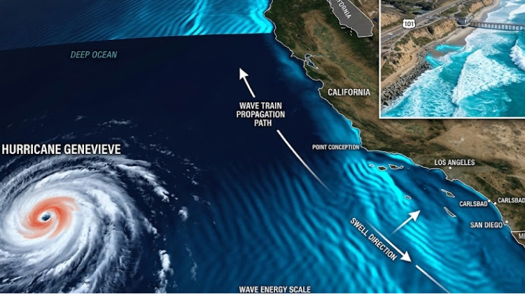
The storm developed in the eastern Pacific and strengthened significantly while tracking northwest of Mexico. On July 28, the National Weather Service reported Genevieve as a Category 3 hurricane with maximum sustained winds of 105 knots, gusts to 130 knots and peak seas near 39 feet. Forecast discussions warned that swells generated by the hurricane would reach Southern California.
Earlier in the storm’s development, Genevieve reached Category 4 strength, with the National Weather Service reporting maximum sustained winds of 115 knots and peak seas near 37 feet on July 29. The resulting swell traveled far beyond the storm’s immediate area.
That distinction matters for California travelers. A tropical system can remain offshore while still producing significant changes along the coast.
Large, long-period waves carry enormous energy. When they reach a sandy shoreline, they can move large quantities of sediment offshore or along the coast in a relatively short period.
At Carlsbad, that process exposed sections of riprap and changed the physical relationship between the beach and nearby infrastructure. The erosion was severe enough that 35 parking spaces were blocked and lifeguard towers were moved.
The National Weather Service’s San Diego office had already warned Southern California beachgoers about dangerous surf associated with Genevieve. Its coastal hazard information described a higher-amplitude swell of approximately 5 feet at 14 seconds, with conditions expected to build from Wednesday into Thursday before gradually subsiding.
For people planning coastal activities, the lesson is straightforward: the storm’s location is not the same thing as the beach’s risk level.
Carlsbad Had Already Added Hundreds Of Thousands Of Cubic Yards Of Sand
The most revealing part of the Carlsbad story is that the beach was not simply waiting for natural sand movement.
Carlsbad beaches had undergone a substantial nourishment effort connected to Agua Hedionda Lagoon. The city reported that up to 400,000 cubic yards of sand would be placed on nearby beaches as part of the lagoon dredging project. The work takes place periodically because sand naturally accumulates inside the lagoon, creating a large sandbar that must be removed.
The material was distributed across Carlsbad State Beaches between Pine Avenue and just north of Cannon Road. The exact placement depended on existing beach dimensions, historical conditions, visitor use and the need to protect rocky ocean habitats.
That makes the latest erosion a useful case study in coastal management.
Beach nourishment can restore recreational space, provide additional protection for infrastructure and improve the appearance of heavily used beaches. Yet the material remains part of a dynamic coastal system. Waves can redistribute it, currents can transport it and large storm swells can move it offshore.
| Carlsbad Coastal Detail | Why It Matters |
|---|---|
| Up to 400,000 cubic yards of sand | Shows the scale of recent nourishment efforts |
| Agua Hedionda Lagoon | Provides sand removed through periodic dredging |
| 35 parking spaces affected | Demonstrates the direct effect on visitor infrastructure |
| Lifeguard towers relocated | Shows how erosion can change beach operations |
| Hurricane Genevieve swell | Demonstrates how offshore storms can reshape California beaches |
The situation also explains why maintaining Southern California’s famous sandy coastline is a continuing challenge rather than a one-time construction project.
A Sandy Beach Can Change Faster Than Visitors Expect
Carlsbad State Beach remains a major recreation destination, offering swimming, surfing, scuba diving, fishing and beachcombing. California State Parks lists the park’s regular hours as 6 a.m. to 11 p.m., with the beach located along Carlsbad Boulevard near Tamarack Avenue.
Those activities depend heavily on physical conditions.
A wide sandy beach gives swimmers and families room to spread out. A narrower shoreline can concentrate visitors closer to the water and nearby infrastructure. Exposed rocks and riprap can create different walking conditions, while stronger surf can make swimming more hazardous.
The change at Carlsbad is a useful reminder that visitors should avoid assuming a familiar beach will look or behave the same way every time they arrive.
The California State Parks Carlsbad State Beach page provides official park information, including current restrictions, hours and visitor details. Checking that information before leaving home is particularly useful after major coastal weather.
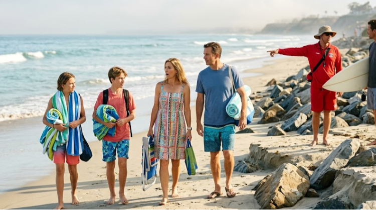
For surfers, the changes may create a different kind of experience. For families and casual beach visitors, the situation calls for more caution. The same stretch of coast can serve very different purposes depending on swell height, tide, shoreline width and lifeguard guidance.
The Erosion Is Part Of A Much Larger Southern California Pattern
Carlsbad is not the only Southern California destination affected by Genevieve.
In Malibu, Point Dume Beach experienced severe erosion after high tides and large swells reached the coast. Los Angeles County officials restricted vehicle access to Westward Beach Road, citing unstable bluff edges and erosion-created drop-offs of up to 8 feet in some areas. The National Weather Service attributed the conditions to the combination of a southerly swell generated by Genevieve and high tides exceeding 6 feet on several nights.
The contrast between Carlsbad and Point Dume shows how the same weather system can create different coastal problems.
At Carlsbad, the most visible issue has been the loss of beach sand and the exposure of protective infrastructure. At Point Dume, erosion affected bluff stability and road access.
The common factor is the energy delivered to the shoreline.
California’s coast is long, varied and heavily developed. Beaches sit beside roads, parking lots, homes, businesses, parks and public facilities. When sediment moves, the consequences can reach well beyond the sand itself.
This is one reason coastal management has become such a significant part of California’s outdoor recreation story.
What The Carlsbad Changes Mean For Summer Beach Visitors
Visitors heading to Carlsbad should approach the beach as a changing environment rather than a fixed recreational space.
The most useful preparation is simple. Check conditions before leaving, pay attention to lifeguard instructions and avoid entering areas affected by erosion or unstable structures.
The National Weather Service had warned that Genevieve-generated swells could produce life-threatening surf and rip currents along portions of Southern California.
That matters even after the storm itself moves away.
Large swells can alter the shoreline, expose objects that were previously buried and change how waves break across the beach. A calmer-looking ocean does not automatically mean that the shoreline has returned to normal.
Visitors should pay particular attention to:
- Temporary closures, barricades and relocated facilities
- Rip currents, sneaker waves and unusually strong surf
- Exposed rocks, riprap and unstable shoreline areas
- Lifeguard instructions and updated park information
The goal is not to discourage people from visiting Carlsbad. It is to recognize that the best beach day depends on conditions, not simply on the calendar.
Sand Replenishment Is Becoming A Bigger Coastal Management Question
The latest changes at Carlsbad raise a difficult question for California: how long can communities continue replacing sand that naturally moves away?
Beach nourishment has a long history along developed portions of the California coast. The approach can provide a wider recreational beach and temporarily protect infrastructure, but scientists have questioned how sustainable repeated replenishment can be as ocean conditions and sea levels change.
Gary Griggs, a coastal scientist and professor at UC Santa Cruz who has studied California beaches extensively, described sand replenishment as a short-term response in reporting on the Carlsbad erosion.
That debate is becoming more relevant as communities balance public access, tourism, environmental protection and infrastructure.
Carlsbad’s recent experience demonstrates the challenge in concrete terms. Hundreds of thousands of cubic yards of sand can be placed on a beach, yet a powerful swell can substantially alter that shoreline within a short period.
That does not mean nourishment has no value. It means its role needs to be understood as part of a larger coastal management strategy.
Carlsbad’s Beach Future Will Depend On More Than Sand
The immediate visual change at Carlsbad State Beach will eventually become another chapter in the coastline’s long history of gaining and losing sediment.
Some of the missing sand may return naturally. Currents and seasonal wave patterns can redistribute sediment along the coast. Other material may remain offshore or move to neighboring beaches.
What happens next will depend on monitoring, weather, ocean conditions and decisions by California State Parks and other agencies responsible for the shoreline.
The current situation gives visitors a practical reason to pay closer attention to the physical condition of the beach rather than relying on photographs or memories from previous trips.
Carlsbad State Beach is still a destination for swimming, surfing, fishing, walking and beachcombing. The difference is that its latest transformation makes the normally hidden mechanics of a California beach visible.
A beach is never really finished.
The sand beneath a visitor’s towel may have arrived from another section of coastline, moved through a lagoon project or been placed there through a nourishment program. A week later, a powerful swell can carry much of it somewhere else.
For California travelers, Hurricane Genevieve has turned that normally invisible process into a highly visible coastal story. The missing sand at Carlsbad is a reminder that public beaches are living systems, and enjoying them safely requires paying attention to the conditions that shape them.