California’s landscape is like a supermodel that needs constant attention. It ranges from Death Valley’s hot conditions to Big Sur’s steep coastal drops. This state can humble you quickly, like a fast-growing startup.
Respecting California’s diverse environments is not about being paranoid. It’s about knowing nature works on its own time, not yours.
Getting ready isn’t just for extreme adventurers. It’s for anyone who wants to come home in one piece. Think of it as a survival guide with amazing views, without the pretence.
California’s beauty comes with its own rules. Learning these rules is not optional. It’s a must for anyone exploring this amazing, challenging state.
Heat Readiness by Region
California’s climate is so varied, it’s like a meteorologist’s dream – or nightmare. The desert is like a natural oven, making water a valuable resource.
Coastal areas seem perfect with their 70-degree weather. But, they hide hypothermia risks in their cool waves. Mountain heights turn UV rays into a silent killer, no matter your sunscreen.
I’ll share heat tips for each region, like a sommelier pairing wines with temperatures. Knowing when to drink water or seek shade is key.
In the desert, staying safe is a must. Drink water before you’re thirsty. Wear light clothes that reflect the sun. Plan your activities for early morning or evening.
Coastal areas may feel cool, but the ocean can quickly lower your body temperature. Always have dry clothes ready.
Mountain areas increase UV exposure. Protecting your skin from the sun is essential. Your skin burns faster, even if you feel cooler.
These tips help you stay safe in California’s diverse climates. Your body didn’t adapt to these conditions, so you must prepare.
Wildlife Awareness: bears, mountain lions, rattlesnakes, sharks, stingrays—avoidance and response
Welcome to nature’s most unpredictable reality show. The cast members have teeth, claws, and no respect for your social media. I’ve had many wildlife encounters, and let me tell you, mountain lions and sharks don’t care about your fame.
The golden rule is to treat wildlife like a quirky relative. Keep your distance, don’t share snacks, and no selfies. National parks say stay 100 yards from bears and wolves, and 25 yards from others. This keeps you safe from becoming part of the food chain.
When Predators Star in Your Adventure
California’s predators are just doing their job well. Your task is to avoid becoming part of their story.
Coyote Protocol: Stand Your Ground
Make yourself look big, yell loudly, and throw objects (not food). They’re testing you—don’t fail.
Wolf Encounters: Slow Retreat
Back away slowly without breaking eye contact. It’s like leaving an awkward party—do it gracefully but deliberately.
Mountain Lion Strategy: Assert Dominance
Maintain eye contact, raise your arms, and make noise. If it comes closer, throw things and stay big. Never run—it triggers their chase instinct.
Bear Essentials: Spray or Play
Use bear spray at 30-60 feet. If you get close, play dead for grizzlies (rare in California) but fight back against black bears. Bears have different rules.
The Non-Predators That Pack a Punch
Big threats can come from animals not trying to eat you. Their defense mechanisms can ruin your day.
Moose and Elk: Run and Hide
Run from these giants. Use trees as barriers—they’re bad at cornering. It’s like dodgeball with high stakes.
Bovine Encounters: Stay Calm
Talk calmly to cows and keep your distance. Avoid herds—they’re like crowded subway cars with 1,500-pound animals.
Remember, wildlife encounters should be stories, not warnings. Your best defense is respecting their space and knowing when to be big, small, or just back away slowly.
Trail First Aid Basics: ABCs, wound care, blisters, sprains, altitude sickness, hypothermia/heat illness
Let’s face it, no one reads Red Cross manuals for fun. Trail first aid is about solving problems with what you have. It’s like survival improv, but with real stakes.
The ABCs – airway, breathing, circulation – are key to not dying in nature. Check these first, before worrying about small injuries. If your friend is turning blue, act fast.
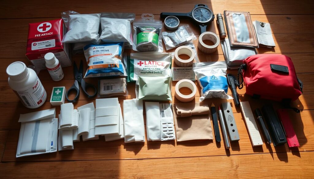
For wilderness wound care, use your water bottle to clean and your buff as a bandage. Remember, dirt is full of bacteria. Clean wounds well.
Blisters are nature’s way of saying your shoes are wrong. Prevent them to avoid treatment. Wear moisture-wicking socks to stay comfortable and avoid blisters.
Here’s how I rank trail injuries:
- Level 1: Blisters (annoying but survivable)
- Level 2: Sprains (ego-bruising plus physical pain)
- Level 3: Altitude sickness (nature’s way of saying “know your place”)
- Level 4: Heat illness (stealthy and dangerous)
- Level 5: Hypothermia (sneaky until it’s critical)
Sprains need RICE – Rest, Ice, Compression, Elevation. Finding ice on a trail can be a challenge.
Altitude sickness is like a bad hangover. It includes headaches, nausea, and dizziness. Descend fast to avoid it.
Heat illness sneaks up on you. Staying hydrated is key. If your urine is dark, drink more water.
Hypothermia makes you lose your mind before you get cold. Listen to your shivering. Wet clothes in cold weather are dangerous.
First aid on trails isn’t about perfect care. It’s about keeping someone stable until help arrives. Your kit should be practical, not ideal.
Remember, your best tool in the wilderness is your brain.
Navigation Essentials: map/compass, GPS apps, offline downloads, waypoints, battery management
In today’s world, we rely on algorithms to find love but worry when Google Maps loses signal. Wilderness navigation is a skill we often overlook. I’ve seen more people struggle with a compass than with their dating app choices – and that’s a lot in California.
Compasses are reliable, unlike your phone’s battery. Map reading is like decoding ancient wisdom. It can save your life when cell service fails.
Digital tools have changed how we explore, but they have their own issues. GPS apps are great until they fail, usually at the worst time.
Essential Navigation Tools Compared
| Tool | Reliability | Learning Curve | Failure Points |
|---|---|---|---|
| Physical Compass | Nearly 100% | Moderate | User error only |
| GPS Apps | 90% | Low | Battery, signal, updates |
| Offline Maps | 95% | Low | Storage space, updates |
| Waypoints | 100% | Very Low | None when properly set |
Offline maps are like extra water – you might not need them right away but they’re vital. Downloading maps before your trip is like having insurance against tech failure.
Waypoints are digital breadcrumbs through California’s varied landscapes. They help you avoid becoming a search-and-rescue statistic. Setting them is simpler than setting your coffee maker and much more critical.
Managing your battery is key. A dead phone when you’re far from home is a sign of poor planning. Treat your power bank like your emergency water supply – because a dead phone is as useless as a broken compass in today’s world.
- Carry a portable charger for 2-3 full charges
- Enable battery saving mode before heading out
- Download maps on WiFi to save data and battery
- Turn off apps and notifications that waste power
- Consider a solar charger for long trips
The smart navigator uses tech wisely, not as a crutch. Digital apps improve safety with analog backups. Your phone might show you a beautiful view, but your compass and map will lead you home when tech fails.
Learning these navigation basics lets you enjoy your journey more. Getting lost should be a metaphor for life, not your weekend plans.
Communication: cell coverage by region, PLBs/sat messengers, check‑in plans
California’s cellular coverage map is like a political promise – full of promises that don’t hold up. I’ve stood on mountain peaks with five bars that vanished quickly. It’s like the politician’s promise changes when the winds shift.
Your smartphone is almost useless outside the city. The state’s varied terrain creates dead zones. These zones are so empty, they feel crowded.
Northern California’s redwood forests swallow signals like a black hole. The Sierra Nevada mountains play ping-pong with your calls. Desert areas offer mirage-like communication – promising but unreliable.
Coastal areas are like unpredictable relatives. One cove might have great service, while the next beach is like being on the moon.
The Satellite Solution: Your Digital Life Preserver
When cell service leaves you stranded, satellite messengers are your lifeline. They work no matter where you are or what you’re doing.
I’ve tried many models and they’ve saved more adventures than my first aid kit. They offer peace of mind worth every penny.
Modern satellite messengers do more than just send out distress signals. They send messages, share your location, and even post your achievements on social media. It’s a way to brag about your adventures while staying safe.
The PLB: No Subscription, No Nonsense
The PLB (Personal Locator Beacon) is simple and reliable. It doesn’t need monthly fees or complicated plans. Just register it and make sure it has batteries.
When you activate a PLB, it sends a distress signal to search and rescue satellites. It’s like pulling the fire alarm – everyone comes to help without asking questions.
PLB devices don’t do two-way communication. They’re a simple, reliable solution for emergencies. They’re like the emergency break glass – effective when needed most.
| Device Type | Best For | Cost Consideration | Communication Style |
|---|---|---|---|
| Smartphone Only | Urban parks and well-traveled trails | Already in your pocket | Unreliable beyond city limits |
| Satellite Messenger | Most backcountry adventures | Monthly subscription required | Two-way messaging and SOS |
| PLB | Life-threatening emergencies only | One-time purchase, no fees | Distress signal only, no messaging |
| Hybrid Devices | Tech-heavy adventurers | Higher initial investment | Combines cellular and satellite |
The Art of the Check-In Plan
A good check-in plan is like leaving a trail of breadcrumbs. It has GPS coordinates and times. I treat mine seriously, like a legal document, because it’s essential in emergencies.
Your check-in plan should include:
- Your exact route and planned variations
- Expected return time with a generous buffer
- Who to call if you’re overdue (and in what order)
- Vehicle information and parking location
- Any medical conditions or special considerations
I’ve seen more adventures saved by a solid check-in plan than by any gear. It’s like telling your mother where you’re going – but now your mother might be a park ranger with a helicopter.
Remember: technology fails, batteries die, and satellites take naps. Your communication strategy should be as redundant as a politician’s talking points.
Carry multiple options, know their limits, and have a backup plan for your backup plan. In the wilderness, cell service is unreliable. Help might not find you without planning.
Packing Checklist by Sport (hike, trail run, MTB, surf, ski)
Packing for outdoor adventures is like assembling a tactical team. Each piece has a specific role, and missing one can ruin the whole plan. I choose gear that’s both military-precise and minimalist, so you don’t carry too much.
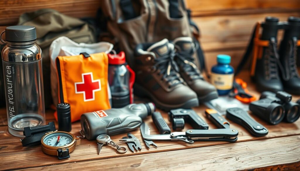
Let’s look at the must-have items for five major California activities. These lists are carefully curated, avoiding unnecessary items.
Hiking: The Mobile Basecamp
Hiking gear should be both comfortable and ready for survival. It’s like packing for a walk that might turn into an adventure.
- Navigation tools: Topographic map, compass, GPS device
- Protection: Sunscreen, wide-brim hat, emergency blanket
- Hydration: 3-liter water capacity, filtration system
- Nutrition: High-calorie snacks, emergency rations
- Safety: First aid kit, headlamp, whistle, multi-tool
Trail Running: The Efficiency Expert
Trail running gear should be light but useful. Every ounce matters when you’re running fast.
- Essential gear: Hydration vest, energy gels, lightweight windbreaker
- Safety items: Compact first aid supplies, emergency contact information
- Navigation: Phone with offline maps, but know your route
- Extras: Body glide, extra hair ties, lightweight gloves
Mountain Biking: The Impact Preparedness
Mountain biking gear needs to handle sudden weather and trail changes. Protection is key when biking fast.
- Protection: Helmet, knee pads, gloves, eyewear
- Tools: Multi-tool, tire repair kit, mini pump
- Safety: First aid focused on impact injuries
- Extras: Trail map, energy bars, hydration pack
Surfing: The Ocean Readiness
Surfing prep means being ready for ocean changes with minimal gear. It’s like predicting the weather but with less stuff.
- Essential gear: Appropriate wetsuit, surfboard, leash
- Safety: Wax, reef booties, first aid for marine injuries
- Extras: Waterproof watch, zinc oxide, changing robe
- Knowledge: Tide charts, swell forecasts, exit strategies
Skiing: The Alpine Survival Kit
Ski packing is about being ready for cold while staying mobile. It’s finding the right balance between warmth and movement.
- Essential gear: Appropriate layers, goggles, helmet
- Safety: Avalanche gear (in backcountry), first aid for cold injuries
- Extras: Hand warmers, lip balm, extra gloves
- Navigation: Trail map, resort information, emergency contacts
Remember, these checklists are just starting points. Your needs will change based on the activity, distance, and difficulty. The smart packer knows when to add special items and when to keep it simple.
The best gear is what you’ll actually use. Not what you think you might need but never do.
Real Scenarios & Decision Trees
Theory doesn’t help when you face a mountain lion or a dead GPS at dusk. These aren’t just ideas – they’re real moments that decide your fate.
Imagine walking the Pacific Crest Trail and suddenly, a 400-pound bear appears 30 yards away. Your heart races. What do you do?
Decision Tree:
- Option A: Freeze and assess → Bear notices you but continues foraging → Slowly back away while talking calmly
- Option B: Run screaming → Triggers predator instinct → You become California’s latest wildlife statistic
- Option C: Make yourself big → Bear stands down → You earn lifetime bragging rights
The best choice? Go from A to C. Never run from predators – it’s like waving steak at a chef.
Scenario 2: Digital Darkness
Your phone dies as coastal fog rolls in. Sunset is 45 minutes away. You’re lost. Panic whispers in your ear.
Decision Tree:
- Option A: Keep moving blindly → Possible injury → Search teams find you cold and embarrassed
- Option B: Stop immediately → Conserve energy → Use emergency whistle → Wait for help
- Option C: Try to find high ground → Risk falls → Maybe get signal → Maybe become night rescue
Option B is always the best. Staying put increases your survival chances. That’s why outdoor survival tips are so important.
Scenario 3: The Solo Mishap
Your hiking partner falls down a slope. They’re okay but can’t put weight on their ankle. You’re three miles from the trailhead with one bar of service.
Decision Tree:
- Option A: Leave them to get help → Risk further injury alone → Possible animal encounters
- Option B: Both try to hobble out → Slow progress → Darkness falls → Hypothermia risk
- Option C: Stabilize injury → Call/text emergency contact → Stay together → Signal for help
Option C is your best bet. Two people have a better chance of survival. Always plan to check in before you start your hike.
These decision trees are not just mental games. They’re survival strategies against California’s wild terrain. Making the right choice keeps your adventure from turning into a scary story.
Quick Reference Cards & Downloadables
In today’s world, waterproof paper is a reliable tech. It never needs charging. While everyone looks at screens, I make analog wonders that beat apps in urgent moments.
These aren’t just any checklists. They’re survival guides with a focus on user experience and real-world use. Imagine wildlife encounter charts so easy, even a top consultant would be impressed.
Why choose paper over digital? It’s because paper works when screens fail. No need for cell service or updates when a mountain lion shows up or a storm hits.
My guides simplify safety rules into quick action plans. They’re like having a survival expert in your pocket, minus the monthly cost.
| Downloadable Type | Best For | Analog Advantage | Emergency Scenario |
|---|---|---|---|
| Wildlife Response Cards | Bear/mountain lion country | Instant access, no loading | Sudden predator encounter |
| Weather Assessment Guide | All mountain/coastal regions | Works without signal | Rapid weather deterioration |
| Trail First Aid Flowchart | Remote medical situations | No battery anxiety | Injury with no cell service |
| Navigation Quick Reference | Complementing offline maps | Always accessible | GPS failure in backcountry |
I test each guide harshly. I’ve even submerged them in water and exposed them to desert heat. They’re tough, so you can be too.
The navigation cards pair well with offline maps. When your phone runs out of battery, these guides take over. They’re your go-to when tech fails.
Download, print, and laminate them. Keep one in your backpack or car. They’re your safety net, ready when you need it most.
In the wild, the best tech is the kind that doesn’t need charging or updates to keep you safe.
Conclusion & Links to Resources
We’ve explored California’s outdoor safety like explorers with modern tools. We’ve learned how to handle wildlife, do basic first aid, and navigate. This knowledge turns fear into action.
Don’t get lost in too much info. I use AllTrails for trail updates, the National Park Service for alerts, and REI’s packing lists. These sources give us what we need to know.
Your next adventure is just around the corner. With the right knowledge and tools, you can explore California’s beauty safely. Stay alert, stay safe, and see you on the trail.