Yosemite National Park remains open, but a fast-growing wildfire near Wawona has closed one of the park’s popular waterfall destinations and several connected backcountry trails. The Dome Fire, discovered on September 15, 2026, roughly a quarter-mile north of Chilnualna Falls, has expanded to approximately 1,177 acres and reached 10% containment as of September 17. The fire is burning in steep, rugged wilderness north and northeast of Wawona Dome, with smoke visible from Wawona Road, the continuation of Highway 41 through the park.
The situation is serious for hikers and visitors in the southern portion of Yosemite, but it is important to distinguish the trail closures from a park-wide shutdown. There are currently no evacuation orders or warnings, and Yosemite officials say there are no immediate threats to developed areas or infrastructure. The principal visitor impact is concentrated around Chilnualna Falls and trails leading toward Buena Vista and Crescent Lakes.
The closure comes during September, when Yosemite’s high-country hiking season is still active and visitors are often seeking cooler temperatures, waterfalls and quieter trails outside Yosemite Valley. For anyone planning a Wawona-area trip, the Dome Fire has changed which routes are available and created additional safety considerations around smoke, falling trees, hot ash and unstable fire-damaged terrain.
The Dome Fire Grew From Five Acres To More Than 1,100
The Dome Fire was first reported on the morning of September 15 north of Wawona Dome. CAL FIRE initially listed the incident at approximately 5 acres, with a moderate rate of spread and zero containment. Within hours, the reported size reached 40 acres and then 100 acres.
By September 16, the fire had expanded dramatically. CAL FIRE reported 300 acres early that morning, followed by an afternoon update listing 1,177 acres with zero containment. The National Park Service described the fire as continuing to move north and northeast while running upslope in alignment with terrain and wind.
By September 17, the fire remained at approximately 1,177 acres, with containment reported at 10%. Fire crews and aircraft continued suppression operations, while the fire remained difficult to access because it is burning in steep and rugged wilderness.
| Date | Reported Dome Fire Size | Containment |
|---|---|---|
| September 15 | 5 acres initially | 0% |
| September 15 | 100 acres | 0% |
| September 16 | 300 acres early | 0% |
| September 16 | 1,177 acres | 0% |
| September 17 | 1,177 acres | 10% |
That rapid increase explains why Yosemite officials moved quickly to restrict access. A fire that expands from a few acres to more than 1,000 acres in roughly 24 hours can create hazards well beyond the visible flame front, particularly in forested terrain where dead trees, burning logs and hidden hot spots can remain dangerous after flames have moved through.
Visitors can monitor the latest Yosemite fire updates through the National Park Service rather than relying on older social-media posts or trail reports.
Chilnualna Falls Trails Are Closed
The most immediate visitor impact is at Chilnualna Falls.
Yosemite National Park has closed the Chilnualna Falls Trail, along with trails extending from the top of the falls toward Buena Vista Lake and Crescent Lake. The lakes remain accessible from the east, but the affected western approaches are closed because of the fire.
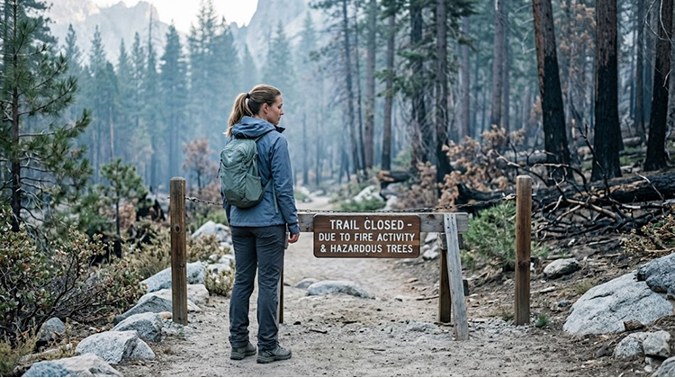
Chilnualna Falls is one of the major waterfall destinations in the Wawona area. The trail follows Chilnualna Creek through granite terrain and forest before reaching a series of cascades and waterfalls.
The closure therefore affects more than a single trail segment.
Hikers who normally use Chilnualna Falls as a starting point for longer backcountry routes cannot simply continue beyond the closed section. The connected trail network creates a larger safety zone because firefighters need room to operate and visitors need to remain away from areas where fire behavior can change quickly.
The National Park Service’s current conditions page confirms that the Chilnualna Falls Trail and the trails leading toward Buena Vista and Crescent Lakes remain closed because of the Dome Fire.
For visitors planning a Yosemite trip, the safest assumption is that a closed trail is unavailable even if photographs or older trail guides still show it as accessible.
Yosemite National Park Is Still Open
The Dome Fire has not closed Yosemite National Park as a whole.
As of the latest official update, Yosemite remains open and operating normally apart from the areas affected by the Dome Fire closure. There are no evacuation orders or warnings, and officials report no immediate threat to developed areas.
That distinction matters for travelers who may see dramatic smoke photographs and assume the entire park has been evacuated.
The main Yosemite Valley visitor area remains accessible, as do many other portions of the park. Wawona Road also remains open, although travelers can see smoke from the roadway.
The fire’s location in wilderness north of Wawona means the current restrictions are concentrated around the active incident rather than extending across every major Yosemite attraction.
Visitors should still check conditions immediately before departure because wildfire closures can change faster than standard seasonal park information.
The National Park Service’s current Yosemite conditions page is the most useful starting point for checking active trail closures, road conditions and other visitor restrictions.
Steep Wilderness Terrain Is Complicating Fire Suppression
The location of the Dome Fire is one of the biggest challenges facing firefighters.
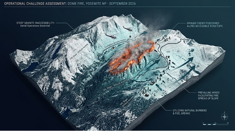
The fire is burning in steep, rugged wilderness, where direct access from the ground is difficult. The National Park Service says crews have been using natural barriers and working with both ground and aerial resources. The fire is moving upslope toward the north and northeast, with terrain and wind influencing its direction.
This type of landscape can make conventional fireline construction slower and more difficult.
Firefighters may have to work around steep slopes, large trees, rocky terrain and limited road access. Aircraft can reach sections of the fire that are difficult for ground crews to access, while natural terrain features can sometimes provide opportunities to slow the fire’s progression.
The challenge is that those same natural features can make the fire harder to monitor from roads and developed areas.
As of September 17, approximately 187 personnel were assigned to the incident, according to the National Park Service’s latest reported figures. Fire crews and air resources continued suppression operations while the fire remained largely in wilderness.
The fire’s movement also demonstrates why the acreage number alone does not describe the full operational challenge. A 1,177-acre fire spread across relatively accessible terrain is a different firefighting problem from a similarly sized fire moving upslope through rugged forest.
Smoke Is Visible From Highway 41
Smoke from the Dome Fire is visible from Wawona Road, the section of Highway 41 running through Yosemite between Wawona and the park’s interior.
The visibility of smoke does not currently mean that Highway 41 or Yosemite Valley is closed. Instead, it provides a reminder that the fire is close enough to a major visitor route to be visible from the roadway.
NASA’s Terra satellite also captured the fire on September 16, showing an active hotspot and a substantial smoke plume. NASA reported that winds carried smoke northwest at lower levels before higher-elevation winds shifted the plume toward the northeast.
That changing smoke direction is relevant for visitors because air conditions can vary substantially over relatively short distances in mountainous terrain.
A clear morning in Yosemite Valley does not necessarily mean that air quality is identical around Wawona or Chilnualna Falls.
For travelers planning outdoor activities, smoke should therefore be treated as a changing environmental condition rather than a fixed boundary around the fire.
The NASA Dome Fire satellite imagery provides an unusually useful visual reference for understanding the fire’s location and smoke movement.
Falling Trees And Hidden Fire Hazards Are Driving The Closure
The trail closure is also about hazards that visitors may not be able to see.
Yosemite’s September 17 safety closure identifies several risks in the fire area, including falling limbs, dead standing trees, fire-damaged trees, burning logs, stump holes, hot ash and smoke-related visibility problems.
These hazards can remain after visible flames disappear.
A tree weakened by fire can fall without warning. A stump or root system can continue burning below the surface. Hot ash can conceal unstable ground, while smoke can make it difficult for hikers to see hazards on a trail.
That is particularly dangerous on steep terrain.
Chilnualna Falls trails already involve elevation changes, rocky surfaces and forested sections. Adding wildfire damage to those conditions creates a risk profile that is very different from an ordinary closed hiking trail.
Yosemite’s current closure order supersedes earlier closure measures and extends the broader safety closure through 11:59 p.m. September 30, 2026, unless officials extend or rescind it sooner.
This does not mean every part of Yosemite is closed through September 30. It refers specifically to the areas identified in the Dome Fire safety closure.
Wawona Is Not Under Evacuation Orders
Despite the fire’s proximity to Wawona, officials currently report no evacuation orders or warnings for the community.
The National Park Service says there are no immediate threats to infrastructure or developed areas. The fire is moving primarily north and northeast away from the community, although officials continue monitoring conditions as suppression operations continue.
Wawona is an important part of Yosemite’s southern gateway and includes historic buildings, lodging and visitor services.
The area’s relationship with wildfire is also significant. Wawona and the surrounding southern portion of Yosemite have experienced major wildfire threats in recent years, including the 2022 Washburn Fire, which burned in the park’s southern region and threatened the Mariposa Grove area.
The current Dome Fire is a different incident, but the repeated exposure of Yosemite’s southern landscape to wildfire highlights the operational challenge of protecting a large national park where developed communities and heavily visited natural areas sit alongside extensive wilderness.
For CaliforniaTimes readers planning trips to Yosemite, the latest Yosemite visitor information is more reliable than assuming that a park-wide status applies to every trail and destination.
Air Quality Remains Part Of The Visitor Risk
Smoke is another reason travelers should pay attention even when they are outside the official closure area.
The September 16 National Park Service update reported air quality in the good to moderate range in Wawona and Yosemite Valley, while the fire continued producing visible smoke. Conditions can change as winds shift and the fire burns different fuel types.
The risk is particularly relevant for people planning strenuous hikes.
Smoke exposure can irritate the eyes and respiratory system, while reduced visibility can make driving and hiking more difficult. Visitors who experience changing smoke conditions should reconsider strenuous outdoor activities rather than assuming that a trail is safe simply because it is technically open.
The AirNow California smoke information is one of the appropriate resources for checking current wildfire smoke conditions before spending extended time outdoors. Yosemite itself directs visitors to AirNow for air-quality information related to the fire.
Weather will remain another important variable. Yosemite’s mountainous terrain produces significant differences in wind, temperature and smoke conditions over short distances, making localized forecasts particularly important during an active fire.
The Cause Of The Fire Remains Under Investigation
Officials have not determined what caused the Dome Fire.
CAL FIRE lists the cause as under investigation, while the National Park Service continues to manage the incident because it is burning inside Yosemite National Park.
The absence of a confirmed cause is significant because speculation can quickly spread during a major wildfire.
At this stage, there is no verified basis for attributing the ignition to a particular person, vehicle, utility or natural event.
Investigators will need to determine where the fire started and examine evidence from the origin area before making a formal determination.
For now, the documented facts are clearer: the fire was reported September 15 north of Wawona Dome, approximately a quarter-mile from Chilnualna Falls, expanded rapidly through grass, brush and timber, and remains active in steep wilderness terrain.
What Yosemite Visitors Should Do Before Heading Toward Wawona
The Dome Fire does not require visitors to cancel every Yosemite trip, but it does require more careful planning for anyone heading toward the southern portion of the park.
The Chilnualna Falls area should be treated as unavailable until Yosemite announces otherwise. Visitors should not attempt to enter closure areas simply because flames are not visible from the trailhead.
Travelers should:
- Check the official Yosemite conditions and fire pages immediately before departure.
- Avoid all posted Dome Fire closure areas.
- Check smoke conditions before strenuous outdoor activities.
- Follow instructions from park rangers and emergency personnel.
- Expect changing conditions around Wawona Road and Highway 41.
- Do not rely on older hiking guides, maps or social-media posts for current trail access.
The distinction between an open park and an open trail is particularly important right now.
CaliforniaTimes has recently covered how wildfire conditions can reshape access to outdoor destinations in its reporting on Northern California wildfire conditions, and Yosemite presents another example of how quickly access can change when fire enters a heavily visited landscape.
The Dome Fire has grown dramatically in a short period, but the latest information does not indicate a park-wide emergency. Yosemite remains open, Wawona is not under evacuation orders, and developed areas are not currently facing an immediate threat. The Chilnualna Falls trail and connected routes are the exception, and those closures are in place because the hazards extend well beyond the visible fire itself.
For hikers, the practical message is simple: Chilnualna Falls is closed, and the closure should be treated as a safety boundary rather than a temporary inconvenience. The fire remains active, conditions can change with wind and terrain, and Yosemite officials will determine when the affected trails are safe to reopen.