

California’s coastline is heading into the fall with an unusual combination of warning signs. Beaches from San Diego County to the Central Coast have already lost substantial amounts of sand after repeated high-surf events, while scientists are tracking an El Niño pattern that could push sea levels higher along the West Coast later this month.
The immediate evidence is visible at places such as Tamarack State Beach in Carlsbad, where California State Parks has closed the day-use parking lot to vehicles after summer swells and high tides eroded significant portions of the beach. State officials say additional high surf and coastal flooding are expected, and there is currently no estimate for when the parking lot will reopen.
At Aliso Beach in Laguna Beach, erosion has already undermined part of the parking area, forcing the city to close a section as powerful waves removed sand from the shoreline. The damage came just as Hurricane Marie generated another round of large Pacific swells along Southern California.
Those locations are more than isolated examples. They provide an early look at what California communities could face if the developing 2026–27 El Niño produces the elevated waves, higher coastal water levels and winter storms that scientists are watching.
California’s Beaches Are Already Starting From A Difficult Position
The current erosion problem did not begin with El Niño. California beaches have been absorbing repeated periods of high surf and unusually energetic ocean conditions throughout the summer.
At Tamarack State Beach, the change has been especially dramatic. NBC 7 reported Sept. 5 that high surf had removed much of the beach’s sand, leaving heavy rocks between the ocean and the nearby parking area. Surfers and swimmers were also encountering a much narrower shoreline and stronger currents.
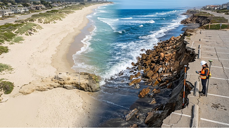
The California State Parks status page now lists the Tamarack day-use parking lot as closed to vehicles while the beach itself remains accessible to pedestrians. The agency says recent summer swells and high tides have eroded significant sections of Carlsbad State Beach.
The situation follows a pattern already documented in other Southern California communities. At Aliso Beach, Laguna Beach officials moved quickly after waves and high tides washed away sand and undermined part of the parking lot. The response included removing damaged pavement and using sand to reinforce vulnerable areas while crews monitored conditions.
For California travelers, these changes matter because beaches are also transportation, recreation and commercial infrastructure zones. Parking lots, access paths, lifeguard facilities, restaurants and coastal roads frequently sit only a short distance from the active shoreline.
That means a beach can remain technically open while losing some of the infrastructure that makes it accessible.
CaliforniaTimes previously examined this problem through the Carlsbad coastal infrastructure risks exposed at Tamarack. The latest conditions show that the issue is continuing rather than representing a single short-lived summer event.
El Niño Could Add Higher Water And Stronger Waves
The next concern is the developing El Niño.
NOAA’s California Current Integrated Ecosystem Assessment reported Aug. 26 that El Niño conditions were already present and expected to strengthen during the Northern Hemisphere winter of 2026–27. Forecast models gave more than a 90% chance of a very strong El Niño during November 2026 through January 2027, potentially placing the event among the strongest recorded since 1950.
That forecast does not mean every California beach will experience the same level of damage. Coastal orientation, beach width, offshore geology, tides and existing infrastructure all influence how individual locations respond.
But California’s recent history provides a clear warning.
The California Coastal Commission reports that the 2015–16 El Niño produced record coastal erosion along many California beaches. Central California experienced an average of about 150 feet of erosion in some areas, while the event generated more than 67 El Niño-related permit actions involving coastal conditions.
A U.S. Geological Survey analysis of roughly 8,000 shore-normal beach transects found that the 2015–16 event produced substantial shoreline retreat across the state. Central California recorded a mean erosion of 45.7 meters, or about 150 feet, while northern California averaged 25.5 meters and southern California averaged 9.7 meters.
| California Coast | Mean 2015–16 El Niño Erosion | Share Of Beaches Showing Erosion |
|---|---|---|
| Central California | 45.7 meters | 96% |
| Northern California | 25.5 meters | 89% |
| Southern California | 9.7 meters | 79% |
The historical data makes the current situation more significant. California is entering a potentially powerful El Niño period while portions of the coastline have already lost sand during the preceding summer.
A Foot Of Temporary Sea-Level Rise Could Arrive This Fall
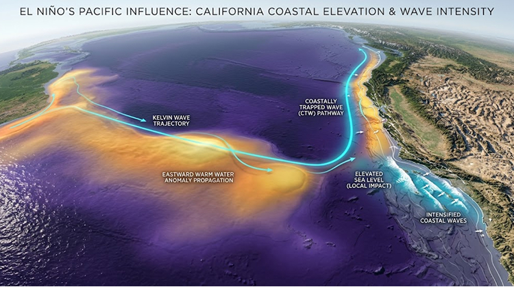
One of the most unusual aspects of the current forecast is a developing coastally trapped Kelvin wave, a phenomenon associated with El Niño that can transport unusually warm water and elevated sea levels northward along the Pacific coast.
NOAA Fisheries reported Sept. 3 that scientists are monitoring ocean indicators for the arrival of a similar signal along the West Coast. Researchers are watching for changes in sea-surface height, ocean temperatures and marine conditions as El Niño strengthens.
Recent reporting from the San Francisco Chronicle indicates that California could see a temporary sea-level increase of roughly one foot beginning in late September, with the signal potentially reaching Southern California and moving north toward San Francisco by early October.
A temporary rise of that scale does not mean every beach will suddenly flood by a foot. The effect depends heavily on tides, waves, coastal geography and storm timing.
The concern is the combination.
When higher water levels arrive at the same time as large waves and high tides, waves can reach farther inland and attack sections of beach that would normally provide a buffer between the ocean and infrastructure.
The NOAA West Coast El Niño indicators are therefore worth watching as California moves deeper into September. The scientific monitoring is focused on detecting the ocean changes before the largest seasonal impacts develop.
Why Sand Loss Can Become An Infrastructure Problem
A wide sandy beach is more than a recreational amenity. It is also a natural buffer.
As waves approach the coast, sand absorbs and redistributes some of the energy. When that sand disappears, waves can reach rocks, seawalls, parking areas, trails and other structures with less material between them and the ocean.
The California Coastal Commission says rising sea levels are expected to increase erosion rates along beaches, cliffs and dunes. The agency also warns that large waves can force water farther inland and increase damage during coastal storms.
This relationship is already visible at Tamarack.
The parking lot did not need to be directly struck by a giant wave to become vulnerable. The loss of beach sand reduced the physical separation between the ocean and the parking area. Continued high tides and surf then increased the potential for additional damage.
The same principle applies at Aliso Beach.
A coastal parking lot can appear stable for years and then become vulnerable after several consecutive erosion events remove enough sediment from the shoreline. Once the protective beach profile changes, infrastructure that previously sat safely inland can become exposed to wave action.
That creates difficult decisions for local and state officials. Temporary sand berms, pavement removal, emergency repairs and beach nourishment can protect facilities in the short term, but each solution has costs and limitations.
The Southern California Coast Is Not The Only Concern
The most visible examples right now are in Southern California, but El Niño impacts can extend much farther north.
The USGS found that the strongest erosion during the 2015–16 event occurred in central and northern California, even though southern beaches also experienced substantial shoreline retreat.
Central California is particularly important because its coastline contains extensive cliffs, beaches, dunes and infrastructure corridors. Highway 1, coastal communities and public recreation areas can all become vulnerable when large waves combine with elevated water levels.
The Coastal Commission identifies coastal roads, utilities, homes, the California Coastal Trail and other development as infrastructure that can be affected by increasing erosion and bluff instability.
That means the coming winter is not simply a beach-management issue.
For coastal communities, erosion can affect access, tourism, public safety and emergency response. For visitors, the consequences may be much more straightforward: closed parking lots, reduced beach space, damaged trails, restricted access and changing safety conditions.
California May Have To Manage Erosion Before The Winter Storms Arrive
The advantage California has this year is that several warning signs are appearing early.
State Parks already has restrictions at Tamarack. Laguna Beach has taken action at Aliso Beach. NOAA is tracking the developing El Niño and associated ocean signals. Researchers are studying current beach conditions rather than waiting until winter storms reach their peak.
The challenge is deciding how much preparation is justified before the full scale of the season becomes clear.
California’s coastal agencies have extensive experience with El Niño-related erosion. The California Coastal Commission records significant damage from previous major events, including the 1982–83 and 1997–98 El Niños. The agency estimates statewide economic damages from the 1997–98 event at more than $1 billion when adjusted to 2015 values.
Those historical events also demonstrate why the same storm can produce very different outcomes from one beach to another.
A heavily armored shoreline may protect a building but lose public beach space. A wide beach may absorb wave energy while a narrower beach nearby exposes infrastructure. A coastal road may remain safe through several storms and then suffer major damage when erosion removes a critical section of its supporting slope.
The California Coastal Commission’s El Niño guidance provides a useful framework for understanding why these effects vary across the state.
What Beach Visitors Should Watch This Fall
For travelers, surfers and local residents, the most useful response is to treat beach conditions as something that can change quickly.
The recent storm activity already produced dangerous surf conditions across Southern California. The Associated Press reported that Hurricane Marie generated waves reaching as high as 10 feet in parts of the region, with officials warning about life-threatening rip currents and urging visitors to stay away from jetties and swim only near lifeguards.
The same ocean conditions that create a safety hazard can also accelerate shoreline erosion.
Visitors should pay particular attention to:
- Closed parking areas, barricades and temporary coastal restrictions.
- Newly exposed rocks, unstable edges, damaged trails and areas beneath eroded bluffs.
- Rip-current warnings and large-wave advisories, even when the weather appears calm.
- Changes to access at popular beaches before making a long drive.
The California State Parks park-status system is also useful before visiting beaches affected by changing coastal conditions.
The Bigger Test Will Come When High Surf Meets High Tides
California’s immediate coastal problem is not simply that El Niño is arriving. It is that the coastline is already showing signs of stress before the main winter season begins.
Tamarack State Beach has lost enough sand for its parking lot to close. Aliso Beach has already required emergency protection after erosion undermined its parking area. NOAA scientists are tracking an El Niño that could become one of the strongest events in the historical record, while researchers are watching for elevated sea levels associated with a coastally trapped Kelvin wave.
The most consequential period may come when several factors overlap: elevated sea levels, high tides, large swells and winter storms.
That combination has produced some of California’s most damaging coastal conditions in the past.
For a state whose beaches support tourism, recreation, wildlife habitat and major transportation corridors, the coming months will provide a real-world test of how much protection California’s existing shoreline can provide—and how quickly communities can respond when the beach itself becomes the first line of defense.